Showing posts with label Peru. Show all posts

Saturday, 16 January 2021

旅游小插曲 (17)

讲过了坐货车游危地马拉的村落,坐独木舟渡过埃塞俄比亚的河,坐草船游览的的喀喀湖的人造岛,再讲一个在秘鲁坐小飞机从天空俯瞰纳斯卡线条的故事。 

在秘鲁西海岸的中部,有个小市镇,名为纳斯卡(Nazca)。附近有个纳斯卡沙漠,这高原沙漠上有很多线条图形,总称是纳斯卡线条(Nazca Lines)。很多只是无意义的单纯线条,不过也有数以百计的各种图案,如几何学图形,花,树,鱼,鸟和其他生物。都是巨型图案,如蜂鸟图案约280米宽。有线条覆盖的地方,面积约50平方公里。线条大约刻于公元前200年到公元700年之间,谁是创造者,为了什么而创造,至今无人能解。这是一个联合国教科文组织世界遗产。

这样的巨型地面图案,不容易观赏,最能一目了然的看当然是从空中俯瞰下来,坐小飞机低飞咯!我们2009年就是坐一架四人小机飞上空,Cessna是小飞机名牌,三位乘客,一位飞机师。全程约三十分钟,每人收费50美元,还有8美元的机场税。另一款的小飞机可坐六个人。 

我们乘坐的这架小飞机的起降非常平稳,归功于飞机师的一流功夫。从地面看上去,这种小飞机就像是一只蜻蜓,悬挂在空中。在飞行过程中,为了方便乘客从窗口看出去可以看得更清楚和拍照,飞机师会把机身调至倾斜一边,左或右,斜度可能达三、四十度。几分钟左,几分钟右,不能适应这种颠簸的乘客就会呕吐。我们三位乘客都是身经百战之士,没问题!

你们可能要问,乘坐这种小飞机有危险吗?哎哟,当然有咯,你走在行人道都有危险啦!这是千载难逢的机会乘坐小飞机,还要想有没有危险吗?下机后才想吧!飞机只有一个机师,如果他心脏病突发,我们就要陪他上天堂,或下地狱了,没有其他选择。我们团中其实有人没乘坐,说是怕呕吐,也不知是不是借口!几年后我在网上搜索一下,2008年有一架小飞机意外撞毁,死了五个人。2010年有两次意外,有13个人蒙难。我们去的2009年没事,阿肋路亞!


旅游小插曲 (16)

上一期坐了独木舟,这一期要讲的是坐草船的故事。不是孔明的草船,那是借箭用的,不载人。我们坐的是南美的的喀喀湖的载人草船。 

的的喀喀湖(Lake Titicaca)是南美洲最大的淡水湖,位於秘魯和玻利維亞交界的安地斯山脈,湖面海拔高3,812米,面積8,290平方公里,比我们的雪兰莪州还大,平均水深140-180米。湖中有三十多個人造島嶼,住有千多名的的乌鲁斯人(Uros),多是捕鱼为生,小部分靠旅游业。

这些原住民以一种属莎草科的長莖長葉挺水植物,整根扎起来紧紧捆绑在一起,编织成小船,用长篙撑驶,驰骋在浅水区。原住民用捆绑起来的草莖做的单人小舟,据说已有三千年的历史。 

编船的植物是长年生的莎草科的一种,叫Totora,长在浅水区,高达46米。样子像芦苇,不过并不是芦苇,芦苇属禾本科。现在编织的船,已不是单人船,而是可坐六个,八个人的船,如所贴的照片中的那艘,两头尖翘,轻巧灵便,我们2009年去时,从一个岛到另一个岛的短距离的收费,好像是一个人三美元。较豪华,中间有凉亭,游艇式的草船也有,大型的可坐几十个人。我们从秘鲁买回来的纪念品就是一艘迷你草船。


Friday, 8 January 2021

The ruins of Machu Picchu, Peru (re-post)

 *WS 02 ( re-post ) – The ruins of Machu Picchu, Peru*

Machu Picchu is an Inca settlement in central-south Peru built around 1450, on a mountain ridge about 2,430 m high. It was abandoned 100 years later when the Spanish came. The Spanish never knew about the settlement and it was not plundered. So it remains as a relatively intact cultural site, a UNESCO World Heritage Site.

The first 2 photos show panoramic views of the upper part of the settlement. The ruins contain about 200 stone structures for housing, sanctuaries, parks and temples. The next 2 photos show the steepness of its slopes on all sides, with many terraces for agriculture. It is protected on 3 sides by the Urubamba River, with steep slopes up to 450 m in height. The 5th shows a dare-evil “bo-kia-si” worker at the edge of the terrace removing weeds. 

The next 3 photos show details of the buildings and then a family group photo. We were there in 2009. Machu Picchu is accessible only by train from Cusco. There is no road link from the site to any other place.


Wednesday, 13 May 2020

The mid-highland city of Arequipa, Peru

*WS 168 - The mid-highland city of Arequipa, Peru*

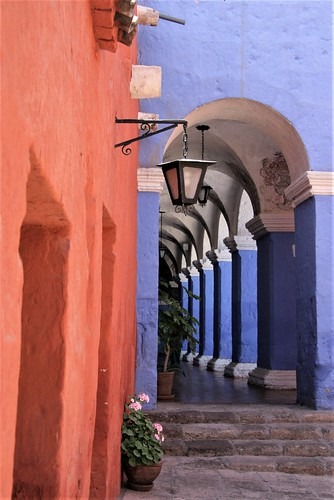
Arequipa is a city located in the mid-highlands of the Peruvian coast with very comfortable weather and a UNESCO World Heritage Site for its well-kept medieval buildings. Population 845,000. We were here in 2009. 

Many of the medieval buildings were built in the Mudejar style imported from Spain, characterised by decorations with stylized calligraphy and intricate geometric and floral forms as used by the Muslim Moors. No icons as Islam prohibits the portray of icons. Other features include the horseshoe and multi-lobed arch, muqarna vaults, moulding around the arches and doors, etc. 

Many older buildings were built with sillar, a soft white volcanic rock. Carving is easy and thus there are many decorative carved elements on the buildings. Over decorated may be. Shown such decoration on the facade of the Church of La Compania of Jesus, and the facade of a bank building, 1st 2 photos.

The main attraction is the Santa Catalina Monastery for nuns, established in 1579, and well designed in the Mudejar style, with vividly painted walls. The monastery is still functioning, but most part of the big complex is open to the fee-paying public as a living museum of Mudejar architecture. The 6th photo shows the simple muquana vaulting and the 8th the decorated doors.


Wednesday, 6 November 2019

The thrill to see the mysterious Nazca Lines from a plane, Nazca Desert, Peru

*WS 108: The thrill to see the mysterious Nazca Lines from a plane, Nazca Desert, Peru*

The Nazca Lines are a group of very large geoglyphs formed on the surface of the Nazca Desert in southern Peru. Most lines run straight across the landscape, but there are also figures. The figures vary in complexity, mostly formed from a single continuous line. Hundreds are geometric shapes and more than 70 are designs of animals. The lines were made by removing the top layer of reddish-brown iron oxide-coated pebbles to reveal the yellow-grey subsoil. The width varies from about 30 to 80 cm, and the depth from 10 to 15 cm. The combined length of the lines totals some 1,300 km over an area of about 50 sq km. 

They were created between 200 BC and 700 AD. Because of its isolation and the dry, windless, stable climate of the plateau, the lines have mostly been preserved naturally. Scholars differ in interpreting the purpose of the designs, but in general, they ascribe religious significance to them. This is a UNESCO World Heritage site.

We visited this place in 2009. The best way to see the geoglyphs is of course from the air. We took to the air in the 4-seater Cessna plane (including 1 seat for the pilot), 1st photo. And this is the most thrilling part of the whole trip. The plane is like a dragonfly “floating” in the air. The small plane did have a very smooth take-off and landing, credit to the pilot. While on the air, to facilitate the passengers taking photos the pilot would tilt the plane to almost 45 degrees on either side. Those who could not take such constant left-right turns might vomit. 

The 2nd photo shows the general terrain of the area. The line figures shown include The Monkey, The Spider and The Hummingbird. The image quality is not good as it was a hazy day and the lines were not that distinctive. The monkey is said to be 100 m by 58 m. and the hummingbird 104 m by 66 m. The biggest animal is the condor, about 134 m by 134 m but my photo of the condor is too poor in quality to be shown here. Other "unrelated" lines in the photos are track marks left by vehicles before they were banned. The painted stones in the last photo are souvenirs, just to show the many types of figures found here.


***************************


Saturday, 20 July 2019

the highland lake of Titicaca bordering Peru and Bolivia

*WS54 – the highland lake of Titicaca bordering Peru and Bolivia*

Lake Titicaca is a large highland lake (altitude: 3,710 m) bordering Peru (55%) and Bolivia (45%), slightly bigger than our Selangor state. Five rivers feed the lake but it has only 1 river outlet. 10% of the water flows out and 90% of it are lost through evaporation, due to strong winds and the intense sunlight at high altitude. This is a very unusual phenomenon.  

The main attractions on this lake are the 30+ man-made islands, called Uros. They are made up with layers of reeds called "totora" and the islands are movable. They are actually inhabited, by about 1,500 people, hunters and fishermen. Some islands are open to visitors for a fee. The hosts would demonstrate how to make things from the reeds, etc. And the boats for their transport are made of reeds too. 

We were here for a few hours in the morning and later had lunch at the shore, grilled fish of course.  

(2009 digital photos, blurry a bit)


Hiking in the Pisac Valley, Cusco, Peru

*WS53 – hiking in the Pisac Valley, Cusco, Peru*

Now to central South America. 

We were in Peru in 2009 (10 years ago) and our group went to the town of Pisac, about an hour’s drive from the old city of Cusco, the former capital of the great Inca Empire. Pisac is located at the eastern end of the Sacred Valley of the Incas. We had a two to three hours’ hike along a mountain ridge to enjoy the vista of the Pisac valley and look at some minor Inca ruins, and meeting some locals. 

The end of the hike led us to the popular Pisac farmers' market (open 3 times a week) where colourfully-dressed locals sell colourful food stuff. See the corns in so many different colours. 

(2009 digital photos, blurry a bit)