Seeing Petra and more in Jordan and Israel/Palestine in 2008
(Travel Story Series @ Hon Too Fang 2021)


Preface
In April 2008 we joined a special group tour to visit the Christian Holy Land in Israel/Palestinian Territories/Jordan. The travel storey is in 2 parts. One part talks about the pilgrimage to the religious sites in Israel/Palestinian Territories. This is the 2nd part focusing on Jordan and the non-religious sites in Israel/Palestinian Territories.
(Note in 2021: the tour was made in April 2008 and the 1st story was written only in June 2013. A lot has changed since 2013, like population figures and the political situations. The information presented here is that from the 2013 story. It is not updated.
Secondly the photos might be low in resolution and poor in clarity as the images from the 1st generation digital camera used in 2008 are of course of an inferior quality compared to what is available now, especially indoor shots in dimly lighted churches.)
A - Jordan
We were in Jordan for a few days. The Kingdom of Jordan has an area of about 90,000 sq km ( bigger than our Sabah but smaller than Sarawak) and a 2012 population of 6.3 million, 98% of them Arabs. About 2 millions are Palestinian Arabs, who fled Palestine in 1948 and 1967 after the Arab-Israel wars. About half a million Iraqi Arabs settled here after the Iraqi War started in 2002, many of them Christians. It is a very dry and poor country, with little natural resources, and depends on US and international aids because of the Palestinian refugee problem. The capital is Amman with a population of 1.5 million.
A1 - Amman
In Amman we celebrated mass at the new and beautiful Church of the Sacred Heart of Jesus, one of 12 Latin-rite Catholic churches in Amman, the capital of a nation with 85% Muslims and 12% Christians. Our tour guide, an Arab Christian, said the construction of the church was funded by the King.


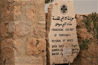
A2 - Mount Nebo, Jordan
Mt Nebo is an elevated ridge about 820 m high located in western Jordan, overlooking the northern part of the Dead Sea. According to the Old Testament it was here that Moses stood to look at the Promised Land and he was said to be buried here too, all happening some 3,500 years ago. But we saw no milk and no honey, only barren slopes.
In 1933 the remains of a monastery and a church, dating to the 6th century were found. Nothing much was left except remnants of mosaic floors. We celebrated our daily mass here at a newly built chapel. The last photo shows the monument of the Bronze Serpent invoked by Moses to cure his people of snake bites in the wilderness.


A3 - Madaba, Jordan
Madaba is a town about 30 km south-west of Amman, famous of its many old mosaics from the Byzantine and Muslim Umayyad periods. Shown part of the town we passed through. Many souvenir shops and souvenirs. The sand art bottles are popular with our group.


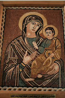
We made a stop at the Greek Orthodox St Georges Church, built in 1897, decorated with many panels of mosaics. Shown with fellow pilgrim and friend Lena and 2 mosaic pieces. The last is not a mosaic but a mural featuring St George.


We came to this church to see the Map of Madaba which originally formed part of the mosaic floor of an ancient Byzantine church in Madaba. It was discovered in 1894 during the construction of the present church and became part of the new church. It is the oldest surviving original cartographic depiction of the Holy Land, especially on Jerusalem. The mosaic map is dated between 542 and 570. The original map was about 21 m by 7 m comprising some 2.3 million tiles, with 150 sites named, from the Nile Delta to Palestine. Due to subsequent fire damage and lack of proper care, some parts were lost. What remains now is about 16 m by 5 m. Shown part of it.

A4 - Petra, Jordan
Our next stop was the ancient of Petra, about 230 km south of Amman. Show typical road scenes in a semi-arid region. The last photo shows the ruins of the Shobak Castle, built by the Crusaders.


Petra, meaning “rock” in Greek, is the most famous archaeological city in Jordan, and a UNESCO World Heritage Site. Over 2,000 years ago Petra was the capital of the nomadic Nabataeans, with a flourishing empire. They developed an elaborate way of water conservation, turning the desert town into an oasis. In 106 AD, the Romans captured Petra and made it a regional capital, but its prosperity soon declined, due partly to changes in sea-based trade routes. A massive earthquake in 363 destroyed many buildings and crippled the water supply system. It remained a ruin for centuries, until the Europeans re-discovered it in the early 1800s.
The attractions are the ruins. From the entrance we had to walk through a narrow gorge to see the ruins. The gorge is called "The Siq", meaning "shaft" in Arabic. Shown steep rock faces of the Siq and stratified rock formation. The picturesque site was featured in the 1989 movie “Indiana Jones and the Last Crusade” starring Harrison Ford and Sean Connery.


The most famous ruin here is the Treasury, a building carved out of red sandstone. But this is only a facade, no actual open space inside despite the name. The architectural details have been eroded over the years. The treasury is located in a giant square with imposing rocks, the last photo.


The civilisation here flourished some 1,600 to 2,000 years ago. Many cave homes were cut into the soft rocks.


Showing more of the interesting features of the rocks. The rock type is sandstone, a sedimentary rock with distinct layers.


The structures in the 1st photo are the Urn Tombs, one in a group of royal tombs, while the 2nd photo shows the remains of the 7,000-seat theatre. Our trip ended after the Hadrian Gate, 3rd photo and the colonnaded street, last photo. It is about 2.0 km from the beginning of the Siq.


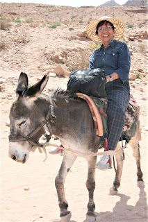
It was a very hot day during our visit. At the end of the route some tourists chose to return to the entrance by camels, horses or donkeys. The auntie in the 1st photo was our member. At the end of the ride she said this was the most terrifying ride of her life. The donkey continued to sway, no harness to hold, she was afraid she might fall down anytime. Shown also young local tourists and Father Frederick among 2 locals in their tribal costumes.


A5 – Resort Hotel in Petra, Jordan
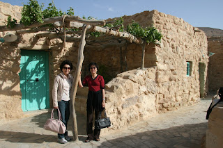
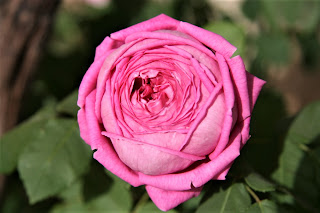
In Petra we stayed at the Taybet Zaman Resort Hotel, converted from a Jordanian village on a hill slope some 9 km from Petra. Unique village stone houses with modern facilities. We had our daily mass at the courtyard. Roses and digitalis are in bloom.


B - Non-religious sites in Israel/Palestine
B1 - Baptismal site on the River Jordan
All four Gospels in the New Testament refer to Jesus being baptized in the River Jordan by John the Baptist. Jesus’ baptism is widely considered as the beginning of his public life and ministry. The Gospel of John names the specific baptismal location as Bethany beyond Jordan. The oldest known travellers’ accounts, dating to 4th century, describe the revered location as being 8 km above where the river flows into the Dead Sea. Since then two locations on either bank of the river have become the baptismal sites for pilgrims. The location on the western bank, controlled by Israel, is called Qasr al-Yahud while the eastern one in the Jordanian territory is called Al-Maghtas.
In 1967 the Six Day War between Israel and the Muslim neighbours broke out. The River Jordan became off limits, including the ancient baptismal sites. In 1981 a village on the bank of River Jordan on the Israeli side was promoted by the local authority as the baptismal site for pilgrimage tourism. This place is called the Yardenit Baptismal Site, very near to the Sea of Galilee and about 100 km north of the ancient traditional baptismal site.
We did visit this site. Since it was obviously not the “real” site, it is placed in this story under non-religious site visited.


(Note in 2021: Both the traditional baptismal sites, Qasr al-Yahud in Israel and Al-Maghtas in Jordan are now open for pilgrimage. In 2015 Al-Maghtas was recognised as a UNESCO World Heritage site, implying that it is the more likely original baptismal site.)
B2 - the Dead Sea
The Dead Sea is really a lake, some 80 km long and up to 18 km wide. It forms a natural border between Israel and Jordan. At 395 m below sea level, it is the lowest lake on earth. It has no outlet, dead. The salt content is 10 times higher than water in the sea, and a person will just float on the surface because of the high density of the water. It is very painful if the water gets into your eyes because of the high salt content. The mineral-rich black mud is also said to be good for skin care. Shown a friend floating on the lake surface and some muddy people!


B3 - Qumran
Qumran is located at the north-western shore of the Dead Sea. Desert neighbourhood. On the way there we passed an area where camel rides were offered to tourists. We do have friends taking up the offer.


In the 1st and 2nd centuries BC, Qumran was home to the Essenes, a small community of Jewish monastic brotherhood who devoted themselves to asceticism. They probably lived in caves and tents. What make this place famous are the Dead Sea Scrolls. In 1949 several shepherds discovered 7 ancient scrolls in a cave. Later archaeological excavations on the cliff faces found many more scrolls and these are called the Dead Sea Scrolls. These are parchment writings made some 2,000 years ago. The dry weather has helped in the preservation of the writing. They include most books of the Old Testament as well as the sect’s own works on rules and codes of ethics. The scrolls are now kept in various Israeli museums.
The place is now a national park. The cave right at the centre of the 3rd photo is where the first scrolls were found by the shepherds. We were viewing it from quite a distance away.


There is a small museum at the visitor centre. Very crowded. Not that we were interested in the old clay bowls but because this was the only place providing shade on a flamingly hot day. And the wild peregrina are blooming in the desert.


B4 - Ruins at Caesarea
Caesarea, about 40 km south of Haifa along the Mediterranean coast and named after the Roman Emperor Augustus Caesar, was a city constructed by Herod the Great in 9 to 22 BC. It is now just a ruin but an important archaeological site in Israel. The harbour is a miracle of engineering, with several inter-connected basins, protected by 2 long breakwaters built with stone blocks with the typical size of 2 m by 4 m by 4 m. However earthquakes have caused the harbour to sink several meters into the sea and very little could be seen today. Other remains are the aqueduct and the amphitheatre. Shown a stone coffin or sarcophagi.


C - Footnote
Our tour has been completed. Our tour leader was George Yeow (g_yeow@hotmail.com). He is seen riding a horse in Petra. And a few photos showing us having our meal at a tent-like restaurant in Amman, before flying home.


(First written in the email format in June 2013. Heavily revised to this PDF format in December 2021)