See the Poor in the Developing World of Ethiopia in 2015 - Part 2 of 2
(Travel Story Series @ Hon Too Fang 2021)
************************
This is Part 2 of 2 on Ethiopia, in the southern region.
************************


Section C: The south
We spent over a week in the Southern Nations, Nationalities and Peoples' Region or SNNPR. The region, south west of Addis Ababa, has a population of 12 to 15 million made up of many ethnic groups. The largest are Sidama at 19%, and Welayta at 11%. Religion wise, Protestants at 55%, Orthodox Christians at 20%, Muslims at 14% and traditional beliefs at 7%.
Awassa
The capital city of this region called SNNPR is Awassa, population about 300,000. It is 275 km south of Addis Ababa in road distance. A long drive from Addis Ababa on the poorly-conditioned roads. Shown roadside scenes near to villages.


Part of the region lies in the Great Rift Valley of Ethiopia. A rift is a linear zone where the Earth's crust is being pulled apart by seismic forces. There are many lakes in the rift valley. The prominent ones are Lake Awassa where the city of Awassa is located on its shore and Lake Chamo at the town of Arba Minch.
Visited a fish market on the shore of Lake Awassa, all fresh catches, typical fishes are catfish and tilapia. A boy selling special bushy straw hats, the Porcupine Mark 3 model. Saw a small colony of black-n-white Colobus monkeys, native to Africa. They are arboreal and important for seed dispersal through their eating habits.


Abra Minch
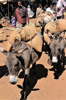
Arba Minch is the 2nd largest city in the region of SNNPR, some 250 km driving distance to the south of Awassa. It has a population of about 180,000. It is our main lodging station to visit the villages of the tribes in the south. Shown some scenes on the journey. The trailer in the 2nd photo is powered by donkeys.


Lake Chamo
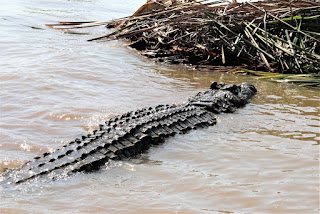
We had a 2-hour cruise in Lake Chamo. Saw some Marabou storks, a few crocodiles and had a glimpse of a huge but shy hippo before it went underwater.


Tribes in the southern region
There is no spectacular landscape or historical sites to see. The attractions here are the ethnic people and their villages, in particular those in the South Omo Zone.
All the tribes in the south are some kind of farmers, except those staying in urban centres. Some tribes who live nearer to towns enjoy some "modern" facilities like transport, power and the better opportunity for education. I group them as "urban" tribes.
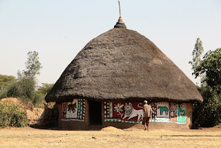
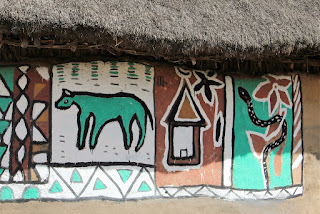
Dorze – urban tribe
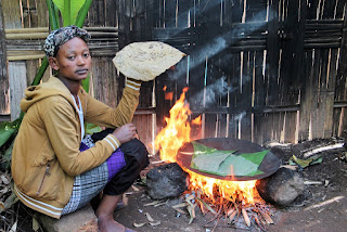
The Dorze is a minority urban tribe, about 30,000 strong, who live in villages near the city of Abra Minch. They live in distinctive tall beehive-shaped huts. The plant shown in the 3rd photo is called the enset, or more commonly known as the False Banana, endemic to southern Ethiopia. It is much bigger than normal banana plants and it does not bear fruits. Starch could be extracted from the stem for food and brew for wine. These fast-growing plants are an important food source in Ethiopia. Their fibre could be used to weave baskets. The girl just cooked a roti canai with the enset flour, to demonstrate to us tourists of course. The Dorze are excellent weavers and our members did buy something from their community store.


Halaba – urban tribe
The Halaba is a tribe, some 130,000 strong, residing in a district named after them in the highlands, west of Awassa and north of Arba Minch. Most of them are Muslims though in the urban centres some are Christians. Their economy is largely based on subsistence dryland farming and raising livestock.
We visited a Muslim family. Their house is big compared to the Druze’s we just covered. It seems their livestock stay inside the same house in the night. The house is well painted for decoration, both externally and on the inside. Shown the proud lady of the house, with a good set of white teeth. She uses Darkie toothpaste.


Aari - urban tribe
Visited a village of another urban tribe, the Aari, which is 280,000 strong. They are a big tribe but subdivided into many subgroups based on their occupations. Some are not farmers. Religion wise some are Christians. This village has a square community hall with thatched roof. Shown a few young children, the big boy played music for us with his special string instrument.


Market by the Gato River
This is a huge weekly market beside the main road by the Gato River about 20 km from Arba Minch. Many people taking bath in the river too; also once a week affair? Trading mostly in grains and also plastic containers for water storage. Mules are the common transporters.


Konso Cultural Village
The Konso Highlands is located at the south eastern part of the SNNPR, near the edge of the rift valley. The town of Konso is about 90 km by road distance from Arba Minch. Shown some roadside scenes from Arba Minch to Konso. The region is generally greener with lush vegetation, but the banana plants seem under-nourished. The 2nd photo shows an old man trying to ask us to visit his church, or buy the merchandise. Ethiopian duck communicating with Malaysian chicken, no understanding.


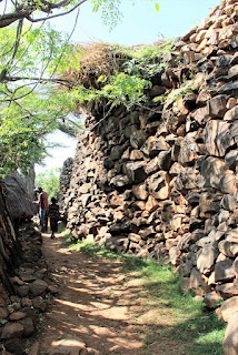
Konso Cultural Landscape
The main inhabitants of the Konso Highlands are the Konso people. The Konso Cultural Landscape is an arid property of stone walled terraces and fortified settlements about 55 sq km in size. It constitutes a spectacular example of a living cultural tradition more than 400 years old adapted to its dry hostile environment. The landscape demonstrates the shared values, social cohesion and engineering knowledge of its communities. The landscape is a UNESCO World Heritage site.
Visited a village. Shown the walls, made of rock and timber. The Konso's round hut has the distinctive double domes.


We visited their community hall. Found a game set very similar to our Malaysian traditional game “chongkak”, 1st photo. The next photo shows the "community generation pole" outside the hall. A pole is added to the bundle every 18 years representing a generation. This village is near to 20 generations old. Lastly boys poking their heads out of the suspended ground floor of the community hall.


We met the official Konso tribal chief too, one Mr Kalla Gezahegn, a 47-year old who spoke good English. He said he was a civil engineer. The government recognises these tribal chiefs to deal with tribal affairs. Shown his palace of 3 huts. The royal entrance gate is shown in the 4th photo. The last 2 photos show royal tomb markers or “waga” located on a hill.


The Lower Omo Zone
The Omo River is the main river in southern Ethiopia, about 760 km long, flowing towards the south and emptying into a lake near the border with Kenya. The Lower Omo Zone is an official administrative demarcation of the region. It is about 21,000 sq km in size. The zone is further divided into 10 administrative districts.
The 2007 census gives a population of 575,000. There are 16 ethnic groups, the largest group is the Aari, about 45%. Religion wise, 50% are in traditional belief, 30% Protestants and 12% Ethiopian Orthodox Christians. According to the 2004 World Bank report, only 4% of the households have access to electricity, 37% of eligible children are in primary school and 7% in secondary school. Not sure what are the more recent data, still a very underdeveloped area that is sure.

Landscape
The villages are far apart, naturally so as the tribes are mostly agro-pastoral. They need grazing ground for their livestock, and some are even semi-nomadic. Shown typical landscape in the valley, mostly flat land.


And what we did encounter? There were very few vehicles on the road, road users were local herdsmen and their livestock. The more interesting ones were a giant ant column and a rare mini baobab tree. Ants nowadays prefer high-rise condominiums, even in Ethiopia. Though the baobab trees are native to Africa we didn’t see them anywhere else except this mini one.


South Omo Research Centre
The research centre is located at the city of Jinka and run by the local university. The mission is to promote intercultural understanding. There were photographs and other exhibits to showcase lives in the South Omo Zone. We were educated a little bit more about the people and the landscape. There was a small museum too.


We visited 4 tribes in the South Omo Zone: Hamar, Kara, Dassanech and Mursi. The map below provides the general location occupied by these tribes.

The Hamar
The Hamar is a tribe, about 50,000 strong, living in a futile part of the valley with the main market town named Turmi. Men rear livestock, mainly cattle. Women plant sorghum, beans, maize, pumpkins, etc. They are famous for their elaborate hairdo, especially the women. They twist the locks with butter and red soil into crimson-coloured dreads. They wear many necklaces and other accessories.
The coming-of-age ceremony for boys is leaping over a line of cattle. We didn’t see that as it was not a frequent event. During the ceremony of cattle leaping, women folks with boys in their families participating in the ceremony would dance to a frenzy and allow the shaman to whip them on the bare backs. Permanent scars are thus formed, considered a sign of devotion to the family. The scars of the girl in the 3rd photo were quite recently inflicted.
The village we went to was a small one, less than 10 huts. Didn’t see any men as they were glazing their livestock in richer pasture somewhere.
Watch out for the elaborate hairdo of the girls.


The Kara
The Kara is a small tribe of around 1,500 to 3,000 people, living in the east banks of the Omo River. They are renowned for their face and body painting, with white chalk, red ochre, yellow mineral rock and black charcoal, etc. All natural resources. The women wear a lot of necklaces. The Kara shares a lot of genetic and cultural linkage with the Hamar.
Their men are renowned for their elaborate hairdo too. This Kara village we visited was a big one with may be 20 huts. But there were no men around, only women and the younger children. The men were glazing their livestock elsewhere. No chance to admire the hairdo of the Kara men.


The Dassanech
The Dassanech tribe numbers about 50,000, living mostly around Lake Turkana near the border with Kenya. They are a primarily agro-pastoral people. They grow sorghum, maize, and other crops when the Omo River and its delta floods. Otherwise the Daasanach rely on their goats and cattle which give them milk, and are slaughtered in the dry season for meat and hides.
The Dassanech tribe is not strictly defined by ethnicity. Anyone, man or woman, from other tribes will be admitted, as long as they agree to be circumcised. Girls, around 12 to 15 years old, are circumcised by having the clitoris removed. There are several sub-tribes.
To reach this particular Dassanech village we had to cross the Omo River (or a tributary) in the wooden dugout canoes shown. 3 or 4 to a narrow canoe. The thin walls of the canoe look very flimsy. Look like it might burst open anytime. Or the canoe might overturn. And I am no swimmer. Any life jackets? The boys might not have seen one before. You don’t have much choice. Just get in, sit tight, keep quiet and pray for the best. In fact the canoe is so narrow we have to be sitting tight. A bigger buttock might not get in even. Once seated the heart started pumping fast to 120 beats a minute.


(Note in 2021: By the way, the Omo River is infested with crocodiles. In fact a Dassanech sub-tribe hunts crocodiles full time in the Omo River for food. Didn’t know that when we were crossing. Otherwise the heart beat could have gone up to 150 beats a minute.)
After we have safely crossed the river without any incident, we had to walk for about 10 to 15 minutes to the village. And the sight of tourists attracted villagers from nearby and everybody walked towards our intended place of assembly in the village. Might be near to eighty or a hundred of them. Everybody eager to become models and be photographed.

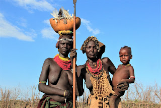
The women decorate themselves with a lot of accessories, like necklaces and bracelets, and elaborate headgear. Often they make a hole in the lower lip and have a flower or a feather pinned onto it, like those in the 1st 2 photos. In the 4th photo, the girl’s crowning glory is made up of bottle caps, quite a show. Still we didn’t see any men.


The Mursi
The Mursi is a tribe living between the Dara Range and the Omo River, close to the border with South Sudan. This is one of the most isolated regions of the country. They number about 11,000, a dark semi-nomadic people. In religion, they are classified as practising animism. Some urban ones are Christians.
At last we saw some men in this last tribal village. The men are reputed fierce warriors. See how "fierce" the 1st man looks. And look at the chest of the 2nd man: it bears elaborate scarification patterns. Then the more friendly-looking father-n-son tag team.


The children have their bodies painted too.


The Mursi women are even more famous. They wear unique clay lip-plates. The woman cuts a slit in her lower lip, puts a clay plate to stretch the opening. The lips are stretched for months, with bigger and bigger plates, the largest about 12 cm. Look at the ear lobes of all these women: they have big openings too which means they might also wear "ear-lobe plates" or hang bigger ornaments. The origin of the practice of lip-plate is unknown, likely to be a symbol of maturity as the women start to cut their lips around 15 years old.
And to accommodate the lip plates, all the 4 lower front teeth have to be removed. How cruel a custom this is? And we tourists help to promote this cruel piece of custom as culture?


Note on scarification: It is to be noted that body scarification was common among several of these tribes in the past. It has since been banned by the government. Only the women of the Hamar tribe continue with the tradition.
Key Afer market
The Key Afer market on Thursday is a big market, involving people from several tribes including the Hamar. We did not go to the main trading ground but instead went to another area where cattle and goats were traded. The cattle were paraded to showcase their quality, the goats kept at a corner and the single rooster cuddled in the arms of the boss.


People came in their tribal costume and buyer/seller crowded in the shade to conduct their business.


Turmi to Arba Minch
The last part of our road journey in the Lower Omo Zone was from Turmi to Arba Minch. Shown some roadside scenes.


We passed by the village of Arbore and had a look at their small market. The measurement for cereal is by cups.


Ending of the tour
From Arba Minch we took a local flight to Addis Ababa and later an international flight back to KL. The tour is ended, but the story continues.
Section D: Further observations
This part consists of my general comments and observations not directly related to any particular place or people.
Food
The national dish is the injera, a large sour-dough flatbread with a spongy texture and made with teff flour. Teff is the fine-grained Ethiopian millet, more expensive. The injera looks and tastes quite like our Indian "tosai". Cheaper ones are made with wheat or corn flour. The injera is eaten with a dhal and/or a vegetable/meat stew. Shown the spongy injera, and a typical breakfast plate consisting of injera with mutton stew for the tourists.


The name "injera" is easy to remember because it sounds exactly like Angela. Now I know why Angela Jodie adopted an Ethiopian child, she must be feeling honoured that the Ethiopian national dish is named after her. Oh, she is really Angelina and not Angela eh? Never mind, nearly loh!
And in every restaurant, when you order eggs, they give you 3 eggs. Everywhere the same. Simply weird. May be 3 is a good number to the Ethiopians. Shown also a plate of chicken rice for tourists.


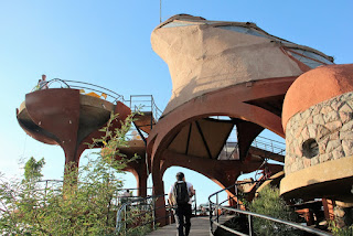
We didn't have pork for 3+ weeks. Many of us missed that greatly. The dominant Orthodox Christians and Muslims both don't eat pork. The Christians would only buy meat from certified butcher shops, those with a cross sign, shown in the 1st photo. The Muslims would of course buy only from the "halal" shops. We did have a very good western dinner at this space-station-like restaurant in Lalibela, called Ben Abeba, run by a Scottish lady. A top rated restaurant there.

We eat a variety of western dishes plus the local ones like the enjera and stews. The meat served, be it beef, mutton or even chicken, is always very tough and need a strong set of teeth to slowly chew them. Our old friend from Penang, PW, was happy with the situation. He could fully try out his new implants still under world-wide warranty.
And your ears enjoy 20 minutes of silence, because your wife is busy chewing a mouthful! And you are eating organic run-around chicken without being charged extra. Everything has a silver lining, PW insisted.
Money Matters
The currency unit in Ethiopia is called Birr. The exchange rate was very roughly 1 RM = 5 Birr. Look at the 1 Birr note, so soiled and torn but still being used. Our tour guide and drivers looked in awe at our washable plastic RM notes.
This is one trip where everyone over-estimated the amount of local currency required. On the last day we had a lot of Birr left to be converted back to US$. And why so? Because there was nothing expensive to shop. Only souvenirs. And coffee. See how big the super-market is in the 2nd photo. "Super" you know! That kind of tiny "super-market", anything to buy? The super-market is found in Lalibela, a town with 15,000 people. We did buy a pair of tribal figurine as souvenirs.


Ethiopian church art
In church paintings posted earlier, you might have noticed that all figures, or icons, are painted having large, almond-shaped eyes. And very often with long noses. The colours used are usually bright and vivid. This is the unique characteristic of the Ethiopian church art. Only good people have big eyes. Evil people are often painted with only one eye, one small eye.
One of the best known examples is found at the Debre Berhan Selassie Church in Gondar, where the ceiling is covered with hundreds of images of angels, one shown. The 2nd photo shows the image of the Virgin Mary and Child found at the Beite Emanuel in Lalibela. The mother and child and the angels all have big eyes and long noses.
Non-religious figures are sometimes presented likewise, as shown in a painting found in a restaurant also in Gondar, 3rd photo. The last photo shows the treasured 18th century manuscript kept at the New Cathedral of St Mary of Zion in Axum, the contents vividly colourful.


Clean water problem
Ethiopia is not a dry country in terms of rainfall. For example for the town of Axum in the far north, the annual rainfall is around 650 mm, quite a wet place. Unfortunately in the north most of the rains fall in the months of July and August leaving other months dry and dusty, making agriculture near impossible. It is even hard to get clean drinking water. Mountain folks have to come down to the valley to collect clean water for their essential needs. Walk for hours.
The ubiquitous yellow container is 25 litre in capacity and it can hold 25 kg of water. Saw many of the people carry such a container on the rural roads, including children. The woman in the 3rd photo was collecting water from a mountain spring in the Asheton Mountain near Lalibela. Her house was only 30 minutes away and downhill, she was lucky. Rainfall in the south is higher and has a better spread over the 12 months, with a second wet spell near November/December.


Road transport
The central and northern part of the country are more developed. We were using a mini bus to move around. Roads are paved and reasonably well maintained.

In the south many of the roads we travelled on are unpaved. That is why we were using 4 x 4 in the south. Three Toyota Cruiser were used, shown one driven by Mr Chuchu. And most rural roads in the south are deserted, practically no passenger cars except the 4 x 4 used by tourists. And some trucks and government vehicles. Private cars are very expensive because of the heavy taxes, ranging from about 130% on the selling price for a small car to 260% for a luxury car. And there are no petrol stations in the more remote areas. Our 4 by 4 were loaded with those 25 litre containers filled with diesel and kept on top of the vehicles.
In big towns the ubiquitous "tut-tut" are handy, painted blue everywhere in the country.


But driving on the road is not easy even if there are not many motor vehicles. You have these to avoid: cattle, goats, camels and mules.


By the roadside
Houses in the rural area, except those round huts belonging to tribes in the south, are inevitably rectangular with timber cladding as wall and a zine roof. The better ones might have part mud-brick walls. Saw a gentlemanly-attired man on his fancifully dressed horse, like going for show jumping, a rare sight indeed. A trailer here is powered not by engines but by donkeys. The last photo shows artificial beehives put up by the farmers to provide "free lodging" to the bees and in return harvest the honey twice yearly. You see, nothing in this World is really free! You may wonder if you will be charged reading this story! Find that out at the end of the story.


In the South Omo Zone, body-painted boys would jump or dance or do some stunts by the roadside when they see a 4 x 4 coming. Hope to entice the tourists to stop and reward them with a Birr or two for their effort, or buy something from them, like papayas in the last photo.


To market, to market
In the south, they have open-air markets in the bigger villages and towns, usually once a week. Villagers walk hours to the market to trade and socialise and gossip, like asking if Big Mama bought any new Birkin bag yet. The one by the Gato River near Arba Minch is huge, 1st photo. Things sold in all these markets are mostly agricultural products, the exceptions are water-containers, shoes and women's clothing. Yes, for women only.


Cereals
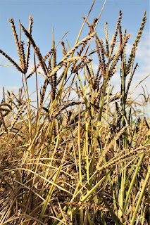
The Ethiopians plant a great variety of cereals. Because our guide Mr Salomon has a degree in agriculture, we learned a lot from him. We were seeing for the first time many cereal plants or oil seed plants which we might have been eating the seeds for years. Showing them in the proper order: red sorghum, barley, teff (Ethiopian millet, extremely nutritious and fine grained), flax seed and soya. The last 2 are not cereals of course


Tough life
It is generally a very tough life out there, for both humans and animals.


Hotels
Our hotels are generally the better ones in town. But if the best in only 1-star you have to make do with that. Anyway the trip is not about enjoying the hotels. We did stay in several resort-type chalets, like this expensive Kanta Lodge in Arba Minch in the south. Mosquito netting was provided over the bed but on this trip we really were not disturbed by mosquitoes. May be this was the dry season. We did stay in a new and modern hotel in Mekelle, the capital city of the Tigray region. Shown the room in the last photo.


Humanitarian gesture
We were aware of how poor the Ethiopians were before we went there. So some of us made full use of the 40 kg luggage limit provided by the Ethiopian Airlines from KL to Addis Ababa and brought along used but good clothes and sports shoes to give to them. On the first day in Addis Ababa we visited a charity home known as "Mekedonia: Home for the Elderly and Mentally Disturbed" and passed over 9 or 10 boxes/bags of the useable old stuff to them. This is a centre with 800+ inmates and 200+ volunteer helpers. Very clean for a congested place. The officer briefed us on their mission and their achievement in the cramped guest room.


We also brought over about 300 Ringgit worth of new stationary, and passed them to a school in a Konso village. They had an old wheel hub hung on a tree to be used as a gong or bell. Very impressive “motto” written on the wall. But look like the teachers have failed miserably: dirty classroom, and students seriously lacking discipline.


Photo Money
Taking photo is not free in Ethiopia, stranger's photo I mean. My wife won't charge me. "Photo Money" are 2 English words every child and woman from the southern tribes know how to say. For the minority tribes in the south modelling is already a profession. They even have an approved scale of professional fees. In general for a fee of 5 Birr (about RM 1) you can take a few shots of the same person. And for a group, each one of them is to be reimbursed the same rate. The helpful local tour guide (specially engaged for the visit to these tribes) has prepared a lot of small change for us to use.
Near the end of the visit to a village, the children and women would pull your shirt and offer a 50% discount, like 2 people for 5 (Birr). They know you are leaving. Might as well make a little bit more. Pre-Christmas sale loh! They are not unionised yet! RM 1 a person is surely not an amount to bargain further, especially photographing naked women. You know how much a ticket cost to watch naked women in Moulin Rouge in Paris?
Happy faces all round: children waiting to receive a ball pen from one of our members. And that is the happy ending of my travel story.

Footnote
I must add that we were totally cut off from telephone and internet communication for 3 or 4 days while we were in the south. Of course there was no mobile phone service, there was no land line service even.
This is a recce trip organised by Yongo Travel (www.yongo.biz). There were 10 of us, all old customers of the company, plus the tour leader Rachel. Thank you, Rachel, for inviting us to participate in this amazing and memorable trip.
And to Mr Salomon, the local tour guide from the company called Witness Ethiopia Tour, thank you too for helping us to know more about your beloved country.
And to you readers, thank you for following this long story. No Tour Story Money asked.
(This story was first written in December 2015 in the email format and heavily revised in this PDF format in December 2021)