Hunza Valley, Pakistan in October 2022
An 11-day tour account to a northern region of Pakistan
(Travel Story Series @ Hon Too Fang, April 2023)


The Islamic Republic of Pakistan
The word “Pakistan” literally means “Land of the Pure” in Urdu and Persian. The land area is 880,000 sq km (Malaysia: 330,000).
History - the region was the site of several ancient cultures, including the Indus Valley civilization of the Bronze Age. It was later ruled by multiple empires and dynasties. From 1757 to 1947, it came under the control of the British, later forming part of the British India Empire. The partition of the British Indian Empire in 1947 resulted in the creation of 2 countries: Hindu-majority India and Muslim-majority Pakistan. Initially Pakistan had two parts with India in between. In 1971 the eastern part became an independent country called Bangladesh.
Government - Since gaining independence Pakistan has been ruled by governments generally alternated between civilian and military, democratic and authoritarian, relatively secular and Islamist. Pakistan is a federation with 4 provinces and 3 federal territories.

Economy - for 2019, the estimated nominal per capita GDP is US 1,388, while the ppp version is US$ 6,800. (Malaysia - 38,200) The major GDP components are agriculture at 21%, manufacturing at 20%, and services at 59%. In manufacturing, the textile industry contributes almost 10% to the GDP.
Population - 242 million, 5th largest in the World. The figure does not include 4 million refugees. The main ethnic groups are the Punjabis (45%), Pashtuns (15%) and Sindhis (14%). Urdu and English are the official languages. Punjabi is the common language for 39% of the people. The state religion is Islam. 96.5% of Pakistanis are Muslims.
Gilgit-Baltistan
This is a region in northern-most Pakistan with an area of 73,000 sq km (double the size of our Pahang state). The region is highly mountainous with 14 peaks over 8,000 m
high, including K2, the 2nd highest peak in the World at 8,611 m. It is administered more like a federal territory though there is some form of autonomy. It is certainly not a normal province. It includes the northern part of the larger Kashmir region which has been the subject of a dispute between India and Pakistan since 1947. The capital city is Gilgit.
The 2017 population is about 1.5 million, consisting of many diverse linguistic, ethnic, and even religious sects. There are many isolated valleys separated by some of the world's highest mountains. Almost all are Muslims, mostly Sunni.
The main economy of the region are trade, agriculture and tourism. Agricultural products are wheat, corn, barley, and fruits. Tourism is growing in importance, with activities like trekking and mountaineering.
Hunza District
The Hunza District is one of the 14 districts in the Gilgit-Baltistan region. It was formed only in 2015 when the former Hunza-Nagar district was split into 2. The area is 11,700 sq km with a population of 243,000. The district capital is the town of Karimabad.

The Hunza Valley
The Hunza Valley is the name of a region with mountainous valleys formed by the Hunza River and its tributaries in the district and beyond. It is not a specific valley. The Hunza Valley floor has an elevation in the 2,500 m range. The region borders China’s Xinjiang province in the northeast, the highest land border in the world.
The people of Hunza
The Hunza Valley region has three main ethnic groups: the Shinaki speakers, the Burushaski speakers and the Wakhi speakers. In religion they are Shia Ismaili Muslims.
The people in the Hunza Valley is famous for being friendly, soft spoken and educated. They number about 60,000. The literacy rate is more than 95%, highest in Pakistan. They enjoy one of the World’s highest life expectancy, due to a diet rich in natural food, clean environment and a lifetime of physical activities like trekking across the region’s rugged terrain. They have very progressive views towards education and women. Their womenfolk are on par with men in social standing. They could be traders, crafts-women, run their own business, wear colourful dresses and travel alone, something uncommon in the Muslim world.
Now we go to see places
So much for the introduction, now we start our tour.
Day 1 and Day 2 - the canceled flight
Our Thai Airways plane landed in Islamabad, the capital of Pakistan in the late evening of Day 1. After a few hours’ rest in a hotel we went to the airport on Day 2 to take an early morning local flight to Gilgit, the capital of the Gilgit and Baltistan region. It is supposed to take 65 minutes. Unfortunately the flight was canceled due to bad weather. There was no other alternative but to go on a road trip. The road distance from Islamabad to Gilgit is about 580 km and it normally takes about 14 to 15 hours. Yes, from 65 minutes to 15 hours! We took much longer than that because we added some sight-seeing stops.
The local tour guide had to make the unpopular decision. The “transit” midi bus which took us from the hotel to the airport became our “permanent” touring bus for the next 10 days. We were soon driving on the famed Karakoram Highway.
Karakoram Highway
The Karakoram Highway, known by its initials KKH, is a Pakistani national highway which extends from Hasan Abdal in the Punjab province to the Khunjerab Pass in the Gilgit-Baltistan region, where it crosses into China and becomes National Highway 314 of China.
The route of the KKH traces one of the many paths of the ancient Silk Road. It is one of the highest paved roads in the world.
Due to its high elevation andthe difficult conditions under which it was constructed, it is often referred to as the 8th Wonder of the World.
Of the 1,300 m length, the Pakistani side has 887 km. Construction started in 1962 and it was completed in 1978, mostly 2-lane.
Reconstruction and upgrading works (to 4 lanes and 6 lanes) on the Pakistani side are currently underway, as part of the $46 billion China Pakistan Economic Corridor.

Starting our road journey
The first part of the road from Islamabad to Hasan Abdul, about 65 km, is a multi-lane motorway. We had our first stop along this part of the motorway. Shown a modern highway rest area like those on the North-South Highway on Malaysian soil.
.JPG)
From Hasan Abdul we were on the Karakoram Highway. Shown scenes of the highway, steep slopes with vegetation, and details of slope protection work. Had another stop at a small town, inhabited mostly by the Pashtun (Pushtan) tribe, one of the most conservative Sunni Islamic group in the World. They make up the largest ethnic group in Afghanistan and the Talibans. We didn’t see any women or girls on the street. Had our first look at the famed decorated trucks of Pakistan.
.JPG)
.JPG)
.JPG)
.JPG)
.JPG)
.JPG)
.JPG)
.JPG)
Day 3 - Chilas and beyond
Had our night stop in Chilas, an old city with 215,000 people. It is a district capital within the Gilgit-Baltistan region. Shown scenes at an open morning market. The locals were interested in us as much as we were interested in them. We were being hunted for photography. But not many have mobile phones though.
.JPG)
.jpg)
.JPG)
.JPG)
Next we had a look at the Thalpan rock carving, a vast gallery of ancient art that includes engravings of animals, Buddhas, religious motifs and inscriptions, etc. The oldest is said dated to 600 BC. These petroglyphs are well scattered. We saw only a few, one piece of rock face shown in the 2nd photo. Big area to hunt for the carving.
.JPG)
.JPG)
.JPG)
.JPG)

Our next stop was at the view point for Nanga Parbat, at 8,126 m above sea level, the 9th highest mountain on Earth. A distant view on a cloudy day. This stop has a small restaurant and we had some hot refreshment in the form of mini cups of Maggie mee.
.JPG)
.JPG)
.JPG)
Jaglot junction point
The next viewing point was the Jaglot junction point of 3 mountain ranges, about 40 km south of Gilgit. It is a unique sight where 3 major mountain ranges in the World meet. The one to the left is the Hindu Kush, about 970 km long. On the right is the mighty Himalaya, 2,400 km long, with 9 of the 10 highest peaks in the World. And in front is the rugged Karakoram, 500 km long with K2, the 2nd highest peak in the World. The river shown is the Indus, 3,200 km long and the Indus Valley is a cradle of early human civilization. Also shown are typical scenes of the landscape in this part of the journey, rugged and barren. Road surface on this part of the Karakoram Highway is in good condition. There was not much traffic because the Chinese border was still closed due to Covid. Otherwise the highway would be heavily trafficked with trucks.
.JPG)
.JPG)
.JPG)
.JPG)
Late lunch in Gilgit
Finally we reached Gilgit, capital of the Gilgit-Baltistan region. Had a very late but good lunch with grilled chicken and freshly caught river trout.
.JPG)
.JPG)
.JPG)
Some scenes at the village where we had lunch.
.JPG)
.JPG)
.JPG)
.JPG)
Day 4 - Yasin Valley
we spent a day at the Yasin Valley, a high altitude mountain valley in the Hindu Kush mountains, within the new Gupis-Yasin district (as realigned in 2019) in the north-western part of the Gilgit-Baltistan region. Made several stops on the rural road running along the Yasin River. First: shots of the river at several locations.
.JPG)
.JPG)
.JPG)
.JPG)
Next: the beautiful landscape shot at ground level.
.JPG)
.JPG)
.JPG)
.JPG)
More to come: scenes at a village with 3 young handsome villagers.
.JPG)
.JPG)
.JPG)
.JPG)
.JPG)
The terrain here is rugged and rocky. The rural road is also much more narrower than the Karakoram Highway. We had picnic lunch at one of the villages on a sunny but cold day.
.JPG)
.JPG)
.JPG)
.JPG)
We are now at some high viewing point to enjoy the autumn vista.
.JPG)
.JPG)
.JPG)
.JPG)
Lastly: at another high point looking at the farms in the valley. The most common trees here are the straight poplars.
.JPG)
.JPG)
.JPG)
.JPG)
Day 5 - Dorkhan Village
This village is located near the town of Ali Abad in the Hunza District (as realigned in 2015). It has about 150 houses. We spent most part of a morning here. Shown early morning scenes in the village, with strong shadows.
.JPG)
.JPG)
.JPG)
.JPG)
More scenes at the village: typical houses, farms, a mosque, a wedding limousine, and part of the Dorkhan Fort built in the 16th century, including a view of the interior.
.JPG)
.JPG)
.JPG)
.JPG)
.JPG)

(photo credit: Polar)
Portrait shots of some of the people we met here. The main ethnic group here are the Burushaski speakers, said to be descendants of the Greek army of Alexander the Great in the 4th century BC. All very friendly, young and old, men and women.
.JPG)
.JPG)
.JPG)
.JPG)
Another village to watch polo practice
Went to a village on the other side of the river to watch villagers practising their polo skill. We crossed the river by using the suspension bridge, this one big enough for tractors to pass.
.JPG)
.JPG)
.JPG)
.JPG)
.JPG)

(Photo credit: Polar)
Day 6 - Karimabad (Baltit)
We are now in Karimabad, the capital of Hunza District, with an estimated population of 16,000. Karimabad is named in honour of Prince Karim Aga Khan, the current spiritual head of the Shia Ismaili community. The old name of the town is Baltit, which served as the capital of the Hunza region for over 750 years, until the formation of Pakistan in 1947. A shot of our hotel, Daastaan Hotel, and the beautiful vista of the valley around our hotel.
.JPG)

(Photo credit: Serene)
Baltit Fort
Baltit Fort is a fort founded about 800 years ago, it has been on the UNESCO World Heritage Tentative list since 2004. The local ruler, called Mir of Hunza, abandoned the fort in 1945, and it started to decay after that. It was restored in the 1990s by an agency of the Aga Khan Development Network. The fort is now a museum.
The fort is of course located on high ground, in fact quite a steep climb from the town. At the lower part of the climb is the bazaar selling mostly goods that catch the hearts of the tourists, including many in our group.
.JPG)
.JPG)
.JPG)
.JPG)
Final steps to the fort and the view of the outer wall from below. The most striking feature to me is the timber canopy over the balcony, designed in Tibetan style. The old canon is named “Zilzila Boos" dated to 1869-70. Caught a glimpse of the guard with his long moustache. He wears the traditional Hunza cap with a feather.
.JPG)
.JPG)
.JPG)
.JPG)
.jpg)
.JPG)
The fort is now a museum. Shown the old royal kitchen
.jpg)
.JPG)
.jpg)
The vista around the fort is of course breath-taking, with autumn colours on show. The old uncle felt good being accompanied by the doctor in the house.
.JPG)
.JPG)
.JPG)

(photo credit: CK)
.JPG)
.JPG)
Ismaili Shia Muslim and Karim Aga Khan
It is necessary to introduce Aga Khan IV at this point of the travel story.
In Shia Islam, the main sect is Twelver Shia who recognize the 12 imams after Prophet Mohammad. The Ismaili is the second biggest sect who have a different list of imans, and they number more than 12. The Hunza people belongs to this Shia Ismaili sect and the Nizari sub-sect.
The current spiritual leader of the Nizari Ismaili is Aga Khan IV, who was born Shah Karim al-Husayni on 13 December 1936. He inherited the imam status in 1957. The Aga Khan claims direct lineal descent from Prophet Muhammad through Muhammad's cousin and son-in-law, Ali. Ali's wife is Fatima, Muhammad's daughter from his first marriage.
Aga Khan IV, the 49th Iman, is a Harvard graduate. He lives in France. He is rated as one of the richest royals in the World. He founded the Aga Khan Development Network, which oversees over 200 non-profit agencies on work of charity, culture, education, etc, etc.
In Hunza Valley his agency has funded the building of many schools, especially those for girls, health centers, restore heritage buildings like the Baltit Fort, etc. Seems well loved by the people here. The town of Karimabad is named after him.
He has received numerous awards, honours and honorary degrees from countries all over the World for his charity work. The right photo is his photo hung at the museum in Baltit Fort.
.jpg)
Altit Fort
Altit Fort is an ancient fort 3 km from Karimabad. It was originally built 1,100 years ago as the palace for the local ruler. The palace was moved to the newer Baltit fort 300 years later. It is the oldest monument in the Gilgit–Baltistan region. It was restored from 2004 to 2007 by a unit of the Aga Khan Development Network. It is characterized by small rooms and low portals with exquisite wood carvings. The vista of the valley from the fort is equally smashing as that from the newer Baltit Fort. The drop of the slope from the fort level to the valley as shown in the 5th photo is near to 300 m. Down there are the blue Hunza River and the winding Karakoram Highway on the opposite bank of the river.
.JPG)
.JPG)
.jpg)
.jpg)
.JPG)
.JPG)
Below the fort is the old Royal Gardens with a restaurant where we had lunch. The 3rd photo shows the waiting area of the restaurant. The string instrument the local musician is playing is the “chardha”, with 5 main strings and 9 resonance strings, a Hunza Valley original.
.JPG)

(photo credit: CK)
.JPG)
.JPG)
Hopper Valley
After lunch we proceeded to Hopper Valley which is located in the Nagar District (as a result of the realignment of the former Hunza-Nagar district in 2016). The connecting rural roads are typical around this area: narrow width, poor road surface, steep and barren rocky slopes, etc. The valley scenes are beautiful though with fall colours at their best: cosmos in bloom and apples in season.
.JPG)
.JPG)
.JPG)
.JPG)
.JPG)
.JPG)
The attraction here is the Hopper Glacier, 28 km long and said to be the 2nd fastest moving glacier in the world. It moves 4 to 6 inches in a day. The Hopper Glacier is blackish because it is a mix of mud and snow.
.JPG)
(photo credit: Joe)
.JPG)
Gojal, Passu and Gulmit
Gojal is a sub-district within Hunza District and Passu is a village in Gojal. The sub-district borders the Xinjiang Province of China. The sub-district capital is Gulmit where we stayed for 3 nights. Gulmit is an historic town where the oldest building is said to be 600 years old. The population is about 5,000.
There are quite a few tourist attractions visited: Passu Glacier, Hussaini suspension bridge, Attabad Lake, Khunjerah Pass and the Gulmit village itself.
Day 7 - Passu Glacier
Passu village is about 20 km from our base in Gulmit. The access road to the glacier is too tough for our midi-bus. We had to change to 4-wheel-drives to reach the base of the trek to view the glacier. Shown the initial roadside scenes, with big pumpkins left on the roof.
.JPG)
.JPG)
After getting off from the 4-wheel-drives we had to trek up a rocky slope to view the glacier. Took us may be 25 to 30 minutes. Slope was not too taxing but the trek was slippery with all the loose stones. Shown threatening sharp rock pieces on the slope above the trek, 3rd photo, and distant landscape on a dull, gloomy and sun-less day.
.JPG)
.JPG)
.JPG)
.JPG)
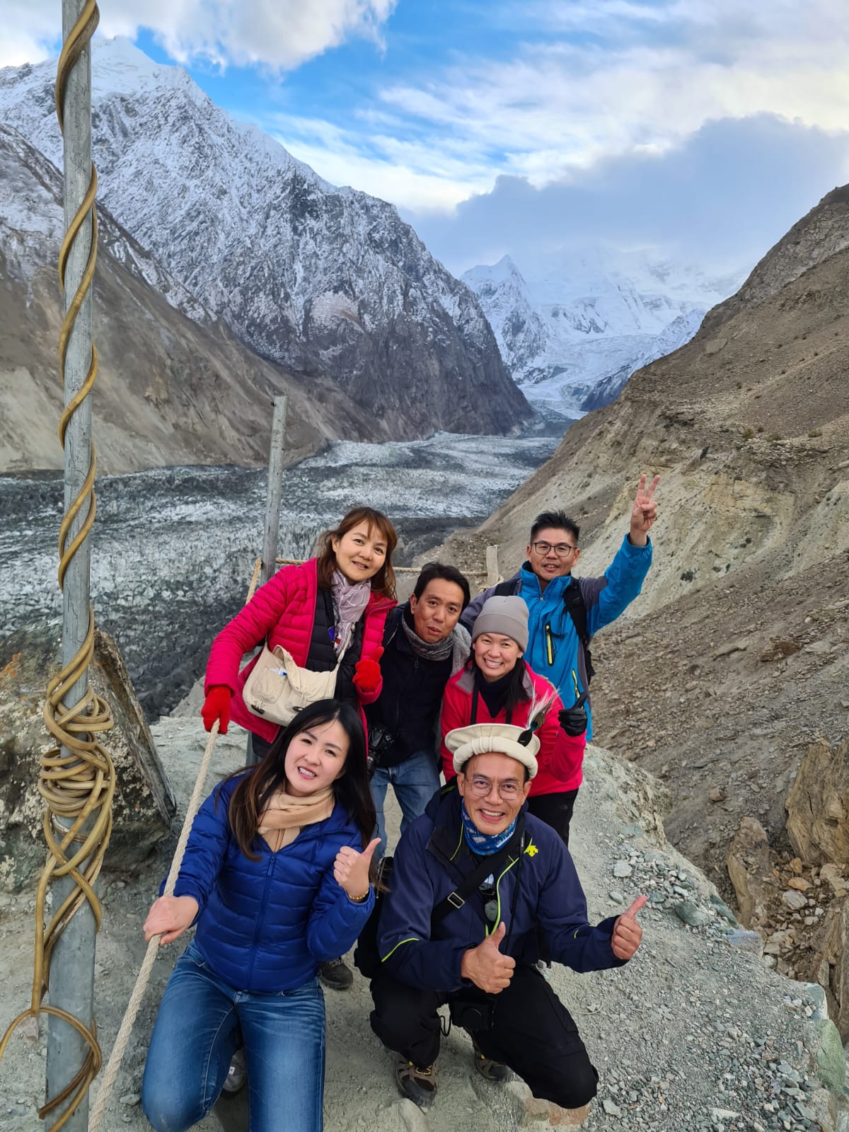
Finally we reached the recommended glacier viewing platform. The glacier is a popular tourist attraction. Some of the people in the 1st photo were not our members. Passu Glacier is about 16 to 20 km long covering an area of 115 sq km. The short and steep flow ensure that it is white as the body is not contaminated with mud.
.JPG)
.JPG)
.JPG)
Borith Lake
Borith Lake is a small saline lake at the elevation of about 2,600 m and located between Passu Glacier and our next destination: Hussaini suspension bridge. We stopped for refreshment here after the tough trekking at the glacier.
.JPG)
.JPG)
Hussaini suspension bridge
Many of the rural river crossings in Hunza Valley are pedestrian suspension bridges, with steel rope and timber planks. The Hussaini bridge connecting the villages of Hussain and Zarabad separated by the Hunza River is just one of the many. The first bridge was built 70 years ago. The current version was dated to 1994 and was recently repaired with new planks. It would sway during windy conditions. The widely-spaced planks with big gaps in between and the sway make crossing this bridge a challenge to tourists. This bridge has thus become a tourist attraction. There are some 470 steps over a distance of 200 m. There was an accident in July 2022 when a tourist was killed after falling into the river. Since then tourists were not allowed to cross the bridge. We could only pose for photos near the pier.
.JPG)
.JPG)
.JPG)
.JPG)
From this place we could see the famous peak called Tupopdan, 6,106 m high.
.JPG)
.JPG)
Home-cooked Hunza food
For lunch we had traditional Hunza food at the home of the tour operator, one Mr Zahir. A bungalow surrounded by trees in autumn colours. We were seated on the floor for the meal. Some nuts as starters. The thin roti is called giyaling or gral, which is a thin stretchy flatbread that is made with whole grain flour. It is typically served in a stack and is dipped in apricot oil and/or butter.
.JPG)
.JPG)
.JPG)
.JPG)
Attabad Lake
A major landslide occurred on 4 January 2010, about 14 km upstream of the Hunza River from Karimabad. The flow of the river was blocked by the landslide debris and a lake was formed. New discharge outlets were opened and flooded many villages, cutting off road links, etc. In all 20 people were killed, 6000 lost their homes and 25,000 people were affected in the disaster. About 25 Km of the Karakoram Highway had to be reconstructed.
The artificial lake so formed is called the Attabad Lake, about 21 km long and over 100 m in depth. The crystal blue lake has now become a big tourist attraction, offering activities like boating, jet-skiing, etc. We had a short cruise-to-nowhere here.
.JPG)
.JPG)

.JPG)
Rainbow Bridge and Passu Cones
In late afternoon we went to see the Rainbow Bridge, a short suspension bridge with planks and piers painted in rainbow colours. Such a simple man-made structure could also attract so many admirers? Simply unbelievable.
Later we drove around the neighbouhood trying to catch a better view of the peak of Tupopdan, the most photographed peak in Hunza Valley. Its nick-name is Passu Cones or Passu Cathedral as it has many sharp cone-shaped mini peaks, like the spires of a typical cathedral building. Due to the low position of the sun, only the peaks were illuminated, anything nearer to ground level would be dark, so no great photo was possible due to such unbalanced lighting condition.
.JPG)
.JPG)
.JPG)

(photo credit: CK)
Day 8 - Gulmit Village
Gulmit, population 5,000, is the capital of the Gojal sub-district within the Hunza District. We stayed 3 nights in the Gulmit Continental Hotel, 1st photo. Since coming to this Hunza region, generally over 2,500 m in altitude, I had sleeping problem. Typical high-altitude problem for me even though this place is not really that high. The cold nights didn’t help too. Slept very little at night. Did have some naps on the bus though.
.JPG)

(photo credit: YW)
On Day 8 of the tour our group was supposed to visit the Khunjerab Pass at 4,693 m in altitude, a place much higher than Gulmit, and much colder too. So I decided to stay back in Gulmit on my own. Our doctor in the house, CK, advised that if I didn’t sleep well, my blood pressure might go too high. It would be a good idea to have it checked too.
In mid morning the boss of our hotel drove me to the government health centre about 1+ km away. The pretty lady doctor had my blood pressures checked and found the readings acceptable. Everything free of charge, including the ride. The health centre was built and being operated by an Aga Khan agency. Remember this agency?
.JPG)
Later I roamed around the nearby village for about 3 hours until mid-afternoon when it was too windy, dusty and cold to continue. Shown shots taken at the commercial part of the village. The 3rd photo shows some of the tents forming a mini heritage museum. The content of the last photo might be appropriate anywhere in the World. The evils of corruption are felt even in such a rural place like Gulmit.
.JPG)
.JPG)
.JPG)
.JPG)
Had lunch at a food hut with traditional food from the Pameri tribe. Yak noodle soup, 2 slices of bread (one already eaten), omelette and a cup of chai (freshly blew milk tea). Cost about RM 12. The only other customer there spoke very good English and said he was a farmer. He praised greatly Dr Mahathir who dared to stand up for the Muslim world. This farmer probably had his time frozen since the day of 911.
.JPG)
.JPG)
Shots taken at the village, narrow paths between loosely fenced houses, and apple trees.
.JPG)
.JPG)
.JPG)
.JPG)
And farm animals.
.JPG)
.JPG)
.JPG)
.JPG)
And lastly autumn colours at their best.
.JPG)
.JPG)
.JPG)
.JPG)
.JPG)
.JPG)
Khunjerab Pass
Khunjerab Pass is a 4,693 m high mountain pass in the Karakoram Mountains, bordering Pakistan and China. It is the highest-paved international border crossing in the world and near the highest point on the Karakoram Highway. It is about 120 km from Gulmit.
I was on medical leave and didn’t visit this place. The photos are taken by the travel mates. Shown scenes along the journey and near the pass. The border-crossing is the small white building at the end of the snowy horizon near the center of the 2nd photo. The travel mates were having a great time playing in the snow, 3rd and 4th photos, perfecting a move called “no-Kit-no-kick”. Sheep came out to play too, last photo.

(photo credit: Polar)

(photo credit: Kit)

(photo credit: KS Ming)

(photo credit: Kit)

(photo credit: Polar)
Near the pass is located the highest ATM in the world, administered by the National Bank of Pakistan. And our midi bus left in isolation.

(photo credit: Janet)

(photo credit: Mabel)
Day 9 - Gulmit to Besham, on the Karakoram Highway
It is about time to go home. The first stage was driving from Gulmit to Besham, about 400 km along the 2-lane Karakoram Highway and it took some 12 hours. The Karakoram Highway is a symbol of the China-Pakistan friendship. Shown typical roadside condition and landscape.
.JPG)
.JPG)
.JPG)
.JPG)
.JPG)
.JPG)
The journey took that long because there were frequent stoppages due to road repair work. See the machines at the top right-hand part in the 1st photo, doing slope repair work. The 2nd photo shows a minor landslide on a section of the road some distance away, dust flying all over. The lighter materials in the 3rd photo are debris of recent landslides. And a souvenir shop at a highway stop, loved by all the lady travel mates.
.JPG)
.JPG)
.JPG)
.JPG)
Day 10 - Besham to Islamabad and in Islamabad
The next stage of the home journey was from Besham to Islamabad, in 4+ hours, some on better tolled highways, initially 2-lane increasing to 6-lane near Islamabad. Had lunch at McDonald’s and a photo stop at the Faisal Mosque, the national mosque of Pakistan, the 6th-largest mosque in the world and the largest within South Asia. It was completed in 1986. The minarets are 79 m high. Of course not impressive at all viewed from a distance.
.JPG)
.JPG)
.JPG)
We were supposed to visit several places in Islamabad according to the original itinerary. However, because of the canceled flight between Islamabad and Gilgit, we had to cover the journey by road instead and as a result we lost one day. So no real sight seeing in Islamabad. Luckily what we wanted to see in Hunza Valley were essentially covered. The last place we visited on this trip was a bazaar in Islamabad, at the request of you-know-who. Nothing worthy to buy though, stuff here more for the locals.
.JPG)
.JPG)
.JPG)
.JPG)
And some colours of the bazaar.
.JPG)
.JPG)
.JPG)
.JPG)
Day 11 - Flying home
The last day was about flying home from Islamabad to Kuala Lumpur/Singapore with transit in Bangkok.
The tour is thus ended. The story would continue for a short while.
Special mention 1: the decorated trucks
One thing worthy for a special mention in this tour are the decorated trucks. Many of the trucks we saw were elaborately decorated. In fact this is something World famous for Pakistan. Truck art is now a distinctive feature of Pakistani culture. Owners invest hundreds or even thousands of US$ to decorate their trucks. The 5th photo shows the colourful decoration on the side of a truck. A decorated small vehicle, last photo, is rather rare though.
.JPG)
.JPG)
.JPG)
.JPG)
.JPG)
.jpg)
(photo credit: Stephanie)
Special mention 2: the journey
The only negative point of the tour is related to the journey. The canceled local flight from Islamabad to Gilgit is of course a huge disappointment. 65 minutes flying time turned into 15 hours on the road. We missed seeing some attractions in Islamabad. We had a tough time to claim our travel insurance too.
Travelling between the small towns and villages was slow due to poor road condition and frequent stoppages due to road repair. Driving on these narrow winding rural roads could be dangerous too, though we never openly discussed it. And luckily nothing happened, thanks to our competent driver. Shown 2 photos of the tougher sections of the journey. Photos taken while on the bus, like live reporting you may say.

(photo credit: KC Tay)

(photo credit: Stephanie)
Tour operator, etc
The tour is marketed by LevArt Travel (www.levart.com.my/en/). An alternative adventure tour provider. The tour leader is Polar, the one on the right in the 1st photo. Together with Kit, they managed to buy our favourite fresh vegetables at the Chilas morning farmers’ market, to be cooked for dinner later in our hotel’s kitchen. This is the beauty of such flexible adventure tour. The local guide is Shah Wali, on a stolen motorbike.

(photo credit: KC Tay)

(photo credit: Stephanie)
The driver of our 24-seater midi bus is Adir aka Mir Mir. He was a former F1 driver. Only F1 drivers could negotiate safely sharp corners in such enlightening speed on the winding narrow rural roads. His front-seat passenger is Kit. Kit had to apply “virtual” brake to help Mir Mir to brake every time the bus comes to a sharp corner. And there were many sharp corners! No wonder Kit complained of leg pain every evening. Just joking!
.JPG)
Thank you, Polar, Shah and Mir Mir for what you have done to enable us to enjoy this memorable trip. I believe all of us are happy about the trip despite the difficult situation.
Group photo
We are a party of 16+1. With 6 Singapore residents. Women out-number men, not surprisingly. All happy faces.

(photo credit: Polar)
Interesting photos taken by travel mates
Presenting some interesting/meaningful/well-taken shots previously posted in our WhatsApp group chat by travel mates. Have to add in some faces, otherwise this story is too cold!
Pretty ladies in a row (with 2 Pakistanis)

(photo credit: Stephanie)
More pretty ladies in more rows (with 1 Pakistani)

(photo credit: Mabel)
Meet the students, led by the Boss

(photo credit: Mabel)
Now led by the Big Sister, youngest in our group

(photo credit: KC Tay)
A yogi on a moving boat

(photo credit: Serene)
Come and shop! No fear!

(photo credit: Mabel)
Human trafficker on the run

(photo credit: Polar)
An honour to be surrounded by many friendly young men

(photo credit: Stephanie)
Concluding note
The story is ended. Thank you readers for reading to the end.
Thank you my travel mates who helped this old uncle, who went alone, in many ways. See you again, my younger friends.
*************
This is a heavily revised version of the daily WhatsApp reports sent out while on tour.