Theme from Silk Road (1) by Kitaro
Re-visiting the Silk Road in China
in 2017 - Part 1/2
(Travel Story Series @ Hon Too Fang 2021)
In May 2017, we joined a group tour to places in the north-west region of China, along the old trade route commonly known as the Silk Road. We covered parts of the Uyghur Autonomous Region of Xinjiang 新疆and provinces of Gansu 甘肃and Shaanxi 陕西. We had our first glimpse of the Silk Road in 1999, also on a group tour. So this is a re-visit.
Silk Road in a paragraph
The term Silk Road used here means a series of trade routes between China and the western regions. It began in the Han Dynasty 汉朝 (207 BC – 220 AD). The name is derived from the lucrative trade in silk sourced in China, but in fact many things were traded, in both directions. And along with trade came exchanges of cultures, religions, philosophies, knowledge, and even diseases, notably plague. Xi'an 西安 in Shaanxi province is generally taken as the eastern end of the road, while the western side has many branches. In 2014 UNESCO designated the Chang'an-Tianshan corridor of the Silk Road as a World Heritage Site. Chang'an is the old name of Xi'an while Tianshan Mountains 天山 is located in the region of Xinjiang.
A - Xinjiang Uyghur Autonomous Region新疆维吾尔自治区
Xinjiang is the largest province/region in China, located in the north-west, with 1.66 million sq km in area (5 times Malaysia). It is split by the Tianshan mountain range, which divides the region into two large basins. One of them is the Turpan Depression 吐鲁番盆地 to the south and it is the lowest point in China.
Population 24 million, 46% Uyghur, 40% Han, 7% Kazakh and 5% Hui. The Muslim Uyghurs are the majority in the southwest, as well as in Turpan to the east. Hans are the majority in eastern and northern Xinjiang including the capital city of Urumqi.
Chinese history first referred to this region as the Yuezhi 月氏 since 645 BC. In the 9th and 10th centuries, the Turkic Muslims came and it became a Muslim region. It was integrated into the Qing Dynasty 清朝 in 1884 when it was named "Xinjiang" meaning the “new territory”. A group led by the Uyghur Muslims has been advocating the establishment of an independent country here, and it has caused tension and ethnic strife in Xinjiang for the last two decades or so.
Traditionally it is an agricultural region, well known for its fruits and other produce, including grapes, melons, pears, etc. Particularly famous are Hami 哈密melons and Turpan raisins.
A 1 - Urumqi 乌鲁木齐
It is the capital of Xinjiang, a major hub on the Silk Road during the Tang Dynasty 唐朝. The name Urumqi means "fine pasture" in Mongolian. General elevation: 800 m, population 3.5 million, made up of 75% Han, 13% Uyghur, 9% Hui. It is the most “inland” city in the world, about 2,500 km from the nearest coastline.
Our flight from KL to Shanghai (transit) was delayed by more than 12 hours due to some air-space security issue in Shanghai. We landed in Urumqi one day late compared to the planned itinerary. So we visited only the 2 main sights.
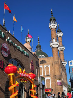
A 2 - Xinjiang International Grand Bazaar 新疆国际大巴扎, Urumqi
It is a large multi-storey bazaar completed in 2002 combining Islamic culture and architecture, commerce and entertainment. With a total area of 100,000 sq m, it lays claim as the largest bazaar in the world.
All kinds of dried fruits and nuts are sold in the bazaar. The most famous are the raisins, many varieties, some with strange names like "Grandpa's Grandpa"! Of course it sells more than nuts, but also souvenirs, handicrafts, minority ethnic groups’ musical instruments, etc.
The place is spacious, clean, orderly, well-ventilated, etc. A first-class setting compared to the dirty and crowded old bazaar we visited in 1999.
A 3 - Red Hill Park 红山公园, Urumqi
Red Hill Park is a public park in the heart of the city. The hill is called Red Hill because it is made up of rock with a reddish brown colour. The hill is 910 m high above the town. The main building here is the Zhenlong Pagoda 镇龙宝塔, built around 1788. Shown the tulips at the entrance, the terrace, the pagoda, and newly-wed on photo-shoot.
Also downtown Urumqi viewed from Red Hill. A very modern city, though Urumqi sounded like “ulu”! And a statue of Lin Zexu 林则徐. Lin (1785-1850) was the Qing Dynasty commanding officer who fought the British in the Opium War in 1839. After the defeat he was demoted and banished to this remote western region. However he was a good and caring administrator. After his death, the locals erected a statue to remember him. Beside the statue is a bronze urn, the type used to burn opium 禁毒铜鼎 as used by Lin.
A 4 - Dinner in Urumqi
The group had a good halal Muslim dinner in Urumqi: signature barbecue, plus lamb shanks, nasi briyani......
A 5 - Tianchi 天池
It is an alpine lake, 45 km east of Urumqi. The name 天池 literally means Heavenly Lake. The lake is 1,907 m above sea level, covering 4.9 sq km, 105 m deep at the deepest point. Tianchi lies on the north side of the sacred Bogda Mountain 博格达山. The people living near to the lake are the Kazakhs. We stayed a night by the lake in two Kazakh's yurts, men and women in different yurts. A very cold night.
The lake is very serene, not many tourists. We spent an afternoon and a morning here, loitering mostly around the lake. The scenic areas in fact include many spots quite far from the lake. Shown a special tree for you to tie your red linen strips written with your petitions or love letters, and traditional Kazakh costume for hire to have your authentic location photo shoot.
There is also a small waterfall cascading over quite a height.
A 6 - Turpan 吐鲁番
Also known as Turfan or Tulufan, Turpan is a city south-east of Urumqi, population 570,000: Uyghur 70%, Han 22%, Hui 7%. Turpan has long been the centre of a fertile oasis and an important trade centre along the Silk Road. In term of history the Han Chinese came into this region around the 100s BC, then Turkic, Han again during the Tang Dynasty, Tibetans, Uyghur and the Mongols in the late 1400s. The name Turfan itself however was used only in the post-Mongol period. Turpan is an agricultural economy.
In the Turpan Depression is this dried-up lake named Ayding Lake 艾丁湖which is the lowest place in China, 154 m below sea level.
A 7 - Karez water system
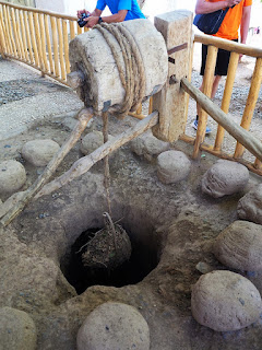
The word karez means "well" in the local Uyghur language. The karez water system is made up of a series of vertical wells that are linked by underground water canals to collect water from the runoff from the base of the mountains. The underground canals would reduce loss of water due to evaporation. The Turpan Depression has over 1100 wells and 5,000 km of channels.
We visited the Turpan Water Museum dedicated to demonstrating its karez water system. The system itself was first used by the Persians in present-day Iran.
A 8 - Jiaohe Ruins 交河故城
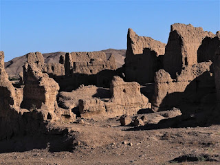
The Jiaohe Ruins is an archaeological site 10 km west of the city of Turpan. From 108 BC to 450 AD Jiaohe was the capital of the Jushi Kingdom 车师, and an important stop along the Silk Road. It was abandoned after its destruction by the Mongols led by Genghis Khan in the 13th century.
Jiaohe was built on a steep-sided plateau 30 m high, on a large islet in the middle of a river which formed a natural defense, which explains why the city has no city walls. The central avenue is 350 m long. It was once home to 7,000+ people.
The ruins we could see today feature Tang Dynasty architectural style. Houses were dug downward from the ground. Wood was rarely used. Owing to the arid climate, the ancient city of Jiaohe remains mostly intact, leaving us a rare example of an earthen castle. It made the UNESCO World Heritage list in 2014. Among the ruins is a piece resembling the Hong Kong actor Eric Tsang 曽志伟. Real photo, unedited.
There is a museum showcasing the history of this region. Shown a model of the city and the bust of Ban Chao 班超 (32-102 AD), a long-serving Chinese commander in this region, known as the Hexi Corridor 河西走廊.
The Flaming Mountains are barren, eroded red sandstone hills at the northern rim of the Taklamakan Desert and east of the city of Turpan. The striking gullies caused by erosion give the mountain a flaming appearance at certain times of the day. The mountains are about 100 km long, 5 to 10 km wide and 500 m in average height, highest about 800 m.
The Flaming Mountains received their name from the popular 16th century classic, Journey to the West 西游记,a fantasy account to the west made by a Buddhist monk accompanied by a monkey king. The monk runs into a wall of flames on his pilgrimage to India. The Uyghur legend has a different explanation on how the mountains were formed. A fierce dragon was slain by a Uyghur warrior and the blood turned into these flaming mountains.
Our tour to this place was a rather unusual one. We actually climbed one of the peaks here to experience the flaming sensation. 1200+ steps along a designated route as shown as a dark straight line in the last photo above. Shown stages of the climb, 1st quarter point, 3rd quarter point, and struggling near the top.
This is the hottest place in China. Not unusual to have highs over 45 degrees (air temperature) in summer. On our day of climb the high (from weather forecast) was 38 degrees. We were up there before 11 am, temperature should be in the mid-30s. The 1st photo (photo credit: TK) shows everybody trying to find a bit of shade from a piece of low rock at the peak.
Due to the low humidity, water and sweat evaporation was extremely fast. Very dehydrating. Within the time of 2 and a half hours there I drank 3 litres of water.
You may wonder why the mountains don’t look “in flame” in the photos. Well, that is a timing issue, my friends. It will look flaming only when the rays of the sun strike the rock gullies at a certain angle, said to be in the late afternoon.
And two shots at the courtyard of the house near our starting point: an old bike shot in sepia and a baby goat (a kid) warming up to the rays of the morning sun.
---------- And that ends our stay in Xinjiang. Next: Province of Gansu ----------
Gansu 甘肃 is a province to the south-east of Xinjiang. Area 450,000 sq km. Most parts are more than 1,000 m above sea level. It lies between the Qinghai-Tibet Plateau 青藏高原 and the Loess Plateau 黄土高原. The Yellow River 黄河passes through the southern part of the province. The population is 26 million, with Han 91%, Hui 6%. The capital is Lanzhou 兰州.
The State of Qin 秦, later to become the founding state of the Chinese imperial dynasties, grew out from the south-eastern part of Gansu, near the Tianshui 天水 area. Since then Gansu became a strategic outpost for China as the so-called Hexi Corridor 河西走廊 (Land West of the Yellow River) runs along the province. The Han Dynasty 汉朝extended the Great Wall here and the Ming Dynasty 明朝extended it further west.
Gansu's economy is based on mining, especially rare earth minerals. It has China's largest nickel deposits accounting for over 90% of China's total nickel reserves.
B 1 - Dunhuang 敦煌
Dunhuang is a county-level city in north-western Gansu, population 185,000. It was a major stop on the ancient Silk Road, at the intersection of all three main routes (north, central, south) and is best known for the nearby Magao Caves 莫高窟. From the west Buddhist monks arrived by the first century AD, and a sizable Buddhist community eventually developed in Dunhuang. In 1227 Dunhuang was conquered by the Mongols who sacked and destroyed the city. A new city started to grow from 1715 during the Qing Dynasty.
Shown some street scenes: a grape-vine covered sidewalk, a commercial building, a pretty Kazakh shop-keeper and Kazakh shoppers. The last photo shows a market cum food court building called "Makan". See the name plate?
In Dunhuang we had home-stay in a single storey building designed as a hostel with many bathroom-attached rooms and a live-in host David and his family. David is a tour operator and guide, not only here but other parts of China. I know of Malaysia groups engaging his service for special group tours. For the morning other members would visit the Crescent Lake 月牙泉 and Singing Sand Dune 鸣沙山 but we stayed behind in the hostel as I was unwell, effects of mild dehydration suffered the day before. We visited these places in 1999 anyway. No great loss.
B 2 - Mogao Caves 莫高窟
Also known as the Thousand Buddha Grottoes 千佛洞, it refers to a cluster of 492 temple caves 25 km southeast of Dunhuang. The caves contain some finest examples of Buddhist arts spanning over a thousand years. It is one of the 4 major Buddhist grottoes in China. The construction of the Mogao Caves is generally taken to have begun sometime in 366 AD. Over a thousand caves were cut. Some have collapsed.
Beside Buddhist art, there were some 50,000 manuscripts kept at a collapsed library cave here, one of the greatest treasure troves of ancient documents found. These scrolls chronicled the development of Buddhism in China, recorded the political and cultural life of the time, giving a rare glimpse into the lives of ordinary people of these eras. The manuscripts were discovered by a monk in 1900 and since then were dispersed all over the world, some sold by the monk, some stolen, some plundered.
Inside the caves are Buddha statues and murals dating from the 5th to the 14th centuries. We visited a few caves. Photography was strictly prohibited inside the caves, where guards were stationed in practically all the caves open for visit. Shown the head of the biggest Buddha statue (35.5 m tall) constructed in 695 and a piece of typical mural, all re-photographed from posters.
Shown exterior views. Platforms have been erected outside the caves to accommodate the tourists so as not to endanger the structural integrity of the natural caves. When we were last here in 1999, there was no such platforms. A few caves even have pagoda-style structures to protect them. The one shown is over Cave No 96, the largest cave. The protective cover is 9-storey high, constructed in 1935 replacing an older one built in 879. The last photo shows a god-fairy in the garden. This type of god-fairy, called Feitian 飞天meaning "flying towards the sky" are very common characters in the early murals, showing the Indian style of dressing.
B 3 – Journey to Jiayuguan City 嘉峪关市
Our next destination was Jiayuguan City, a prefecture-level city about 370 km east of Dunhuang, population 230,000. A long drive on highways without much traffic with monotony punctuated by modern "windmills".
B 4 - Jiayu Pass or Jiayuguan 嘉峪关
It is the pass at the west end of the Great Wall, located at the narrowest point of the western section of the Hexi Corridor, 6 km southwest of the city of Jiayuguan. The structure was built during the early Ming Dynasty, around the year 1372. Among the passes on the Great Wall, Jiayuguan is the best preserved surviving ancient military building in China, nick-named "First and Greatest Pass Under Heaven" 天下第一雄关.
In Chinese history Jiayuguan has a special significance. It was here that people, usually court officials, who were banished to the west would have to leave through and the vast majority never live to return. Among those once banished in disgrace was the Opium War commander Lin Zexu, who died in Urumqi.
The pass has a perimeter of 733 m, wall height of 11 m and an area of 33,500 sq m. There are 2 gates each with a building. Shown at the main gate and part of the giant copper tooling at the entrance showcasing the details and history of the Great Wall.
Internal views of the pass: general layout, a pavilion, and a sepia shot of the opening in the thick wall.
Buildings inside: commander’s office, a shrine, barracks and a stage for opera show.
Inevitable commercialization: 10 strikes of the good-luck giant drum cost you 10 Yuan (RM 6.50). Only in China. And bicycles for hire outside the entrance gate (to ride in the public park outside the pass, not inside the pass).
B 4 - Cliff Wall at Shiguanxia 石关峡悬壁长城
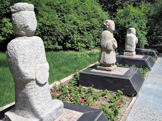
About 7 km north of Jiagu Pass is a section of the Great Wall which was built on a steep ridge, at a place called Shiquanxia 石关峡. We had a brief stop here. The younger and fitter ones did go up to the ridge but we stayed behind. Shown also statues of prominent historic people relevant to this part of the country at the statue park at the entrance.
B 5 - Wei and Jin Tombs 魏晋墓, near Jiayuguan
18 km east of Jiayuguan is a place called Guoyuan 果园. There are many old tombs dated as far back as the Wei Dynasty 魏朝 and Jin Dynasty 晋朝 or roughly from 3rd to 6th centuries AD. In 1972 eight tombs were dug and explored.
Inside the tombs were found more than 600 pieces of fired wall tiles with simple painting on them. The scenes depicted include a wide variety of activities in everyday life. We went into one of the tombs. A tomb is like a small house with areas reserved for different purposes. Photography was not allowed inside. Photos posted here were taken at the small museum: 2 pieces of wall tiles, a coffin, and a shot of a giant poster showing the interior of a tomb.
B 6 - Jiuquan 酒泉
Jiuquan is a city located in the northwestern part of the province, population 1.1 million. It was one of the four counties crossed by the Silk Road in the old Hexi Corridor during the Han Dynasty 汉朝 (207 BC - 220 AD). The name Jiuquan, "Wine Spring", is derived from a legendary story of the Han general Huo Qubing, 霍去病. Huo won a battle with the nomads. The Emperor awarded him a vat of special wine. Since the amount of the wine was so little, he poured it into a local creek so that all his troops could share it by drinking the water from the creek. The creek became the “Wine Spring”.
The main attraction of the present city is the “Lake Park 酒泉公园”, the only garden of the Han Dynasty in the Hexi Corridor still surviving today and well preserved too. There are many buildings of classical design, of course most are rebuilt versions. The signature attractions are the Wine Spring and the Zuo's Willows. Zuo Zongtang 左宗棠 was the Governor of this region during the Qing Dynasty from 1866 to 1881. He ordered the planting of many trees to help reduce the effects of sand storms and to beautify the city. Some of the trees survived until today. The few inside the park are said to have been planted by Zuo personally. These are called “Zuo’s Willows 左公柳”.
A well maintained and decorated park. The 4th photo shows the Wine Spring and a Zuo's Willow at the back. The last photo shows part of the small sculpture park showcasing the troop of General Huo.
There is a building dedicated to the display of works of calligraphy and seals by old masters.
To be continued……….


No comments:
Post a Comment