Be Mesmerised by Nature in New Zealand in 2013
Part 2 of 2
(Travel Story Series @ Hon Too Fang 2021)
B 9 – Queenstown, west coast, South Island
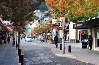
Queenstown, population 29,000, is the main resort town and adventure centre in NZ. Shown street scenes, Lake Hayes located at the edge of the town centre and autumn leaves.
Bungee jumping
The first commercial bungee jumping in the World was held in Auckland, New Zealand in 1986. And the first permanent jumping site was set up in Queenstown in 1988. It was at the Kawarau Gorge Suspension Bridge. The deck is 43 m over the water. We witnessed a jump here. None of our members dared to take part though one nearly did.
Bob’s Peak
Bob’s peak is 480 m above the town and reachable by cable car. It offers a panoramic view of the town and the adjacent ragged mountains. The famous trilogy "Lord of the Ring" was filmed on location on top of some of these mountains. Shown also a tandem parachute jump in action.
One activity some of us did take part is the Luge cart ride, a thrilling gravity-propelled ride in the 3-wheeled Luge carts.
B 10 - Arrowtown, near Queenstown
Arrowtown, population 2,200, was a former gold mining town established in the 1860s. There was a Chinese miners’ community here. Shown 2 photos of some restored buildings, with an old door locking mechanism. The Bush Creek bordering the town offers tranquil autumn scenery.
Buckingham Street
The main Buckingham Street itself is flooded with nice flower pots and big cute soft toys.
B 11 – Queenstown to Te Anau, west coast, South Island
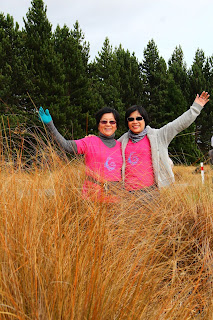
Our next stop is Te Anau, some 170 km to the south west of Queenstown via State Highway 6. We passed through a red tussock conservation area. The red tussock is a very hardy tall grass endemic to NZ. Shown with PH.
Te Anau is a small lakeside town and gateway to Milford Sound. The takahe, the endangered flightless bird, could be found here. What we found was a statue though. And pies from this Miles Better Pies café is excellent, as recommended by Lonely Planet.
B 12 – Te Anau to Milford Sound, west coast, South Island
This is also a very scenic journey, 180 km north bound. Most part of the journey come within the Fiordland National Park. Places we took walks include the Chasm Walk noted for water-sculptured shapes of rock and the rain forest, 1st 2 photos, and the Mirror Lakes, with clear reflections of the Earl Mountains, 3rd and 4th photos. And other sights.
B 13 - Milford Sound, west coast, South Island
In geography, a "sound" is a narrow channel between two bodies of land. A sound produced by a receding glacier on the coast is called a fjord. Milford Sound which is a fjord runs 15 km from the Tasman Sea and is surrounded by rock faces rising 1,200 m or more on either side.
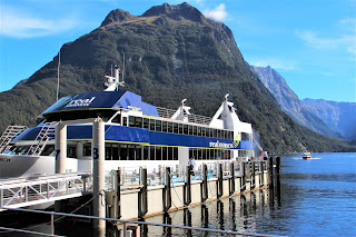
It is a top tourist attraction in New Zealand, despite it being located in a more “remote” area. The nearest town, Te Anau is 120 km away. Tourists normally make a day trip here and see the fiord landscape on a boat cruise for up to 2 hours. And we did exactly that.
Milford Sound is a very wet place, with annual rainfall of 6,400 mm. It is normally considered as the wettest place in NZ. About every other day is a rainy day. We were thus very lucky as it was a gorgeous sunny day during our cruise. The water is ink-dark because it is deep, up to 400 m. The 3rd photo was taken at the car park. The most visible wildlife are the fur seals, 4th photo.
There are 2 permanent waterfalls, shown the Bowen Falls at 161 m height. There are many semi-permanent falls, like the Fairy Falls, 285 m high.
B 14 - Te Anau to Invercargill, west coast, South Island
From Te Anau we went south to Invercargill, 150 km away. Had a “wet” walk at the Rataku Wetlands, newly established in 2006. A bus-shaped bus stop and sheep on a roadside farm.
B 15 – Invercargill, south point, South Island
Invercargill with a population of 55,000 is the southernmost city in NZ. The notable buildings here include the St Mary’s Catholic Cathedral built in 1905 with a 37 m high dome, and the iconic Water Tower constructed in 1889, 31 m tall. An ornate red-brick building with large windows, exceptionally beautiful for a utility building.
We also visited the botanical garden in Queen’s Park, shown the hydrangea.
Stirling Point
Stirling Point, 25 km south of Invercargill, represent the southern end of State Highway 1. It has an old lighthouse on the rugged coast. Shown the anchor chain sculpture and the iconic signpost displaying distances to major cities in the world, a must-pose for tourists.
B 16 – Invercargill to Dunedin, east coast, South Island
From Invercargill we went northeast to Dunedin, about 270 km away, via the Catlins which is the area in the south-eastern corner of the South Island. Shown initial landscape and a “windswept” tree.
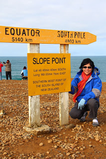
Slope Point
The first major attraction is the Slope Point, the southern-most point of the South Island. We had to walk about 15 to 20 minutes on the edge of a sheep farm to reach the place.
Curio Bay
The attraction is looking at the 180 million year old Jurassic fossil forest at low tide, said to be only 1 of the 3 such fossil sites in the World. The 3rd and 4th photos show some petrified tree trunks. There are supposed to have yellow-eyed penguins here but we did not see any. Saw only the cute silver gull and giant seaweeds.
Florence Point Lookout
The smooth coastline looks picturesque from the lookout. Even the cattle came to admire.
Nugget Point
This stretch of the coast is dotted with boulders with the iconic Tokata lighthouse built in 1869. It offers a spectacular panoramic view of the coast.
B 17 - Dunedin, east coast, South Island
Dunedin, with a population of 100,000, is the 2nd largest city in the South Island. Shown 3 street scenes in the city centre, with one showing people queueing to collect natural spring water provided by the Speight Brewery. The 4th photo is a shot of Baldwin Street at the suburb, the steepest street in the World, as recognised by the Guinness World Records. The upper part has a slope of 1:2.86.
Railway Station
The city is famous for some beautiful buildings. Topping the list is the Railway Station with a beautiful interior decorated with mosaics. The exterior was shot on a dull rainy morning.
The First Church of Otago
This is the main Presbyterian church in the city, completed in 1873 to replace an old one built in 1848. It is in the classic decorated Gothic style, with the main spire up to 56 m high, and an impressive rose window.
Market and beach
And at the Otago Farmers’ Market and the Broad Bay beach.
Portobello Happy Hens
This is a famous workshop producing brightly painted colourful ceramic hens and roosters, located at the suburb of Portobello. It was started by an art teacher Yvonne Sutherland some 20+ years ago. Very cute indeed.
B 18 – Dunedin to Mt Cook National Park, east coast, South Island
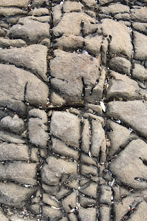
The national park is about 290 km by road from Dunedin, to the north. First passed by Koekohe Beach where the attractions are the Koekohe boulders, a group of unusually large and spherical boulders, most are between 1.5 to 2.2 meters in diameter. They consists of mud, fine silt and clay cemented by calcite. The broken ones, broken at the centre at the top, look like the eggs of the aliens in the 1979 movie “Alien”.
Visited a salmon farm in the later part of the journey in a picturesque autumn setting.
B 19 - Mt Cook National Park, central, South Island
Mt Cook, at 3,754 m, is the highest mountain in NZ. The National Park is part of a group of 4 parks constituting a UNESCO World Heritage Site. At the Mt Cook Village we stayed at the chalet type of accommodation run by the Armitage group. Shown views of the surrounding mountains on a gloomy misty day.
Hooker Valley Track
The next morning we embarked on the 3+ hour Hooker Valley Track hike, which would lead us to the foot of Mt Cook. About 5 km each way. We were not climbing any peak, but just walking along the side of the mountain range trying to reach the foot of Mt Cook. So it was not a difficult walk. Unfortunately it was drizzling on and off all morning and we made a U-turn after completing about half to two-thirds of the intended hike. Couldn't see far because of the mist and certainly no chance to see the peak of Mt Cook.
Flora
The land is rocky so there are no forests despite the high rainfall. The meadows are mostly covered with long snow tussock grass, with pockets of other plants like the golden speargrass in the 2nd photo, and the thorny matagouri shrub in the 3rd photo. The last is snow totara, a common subalpine shrub endemic to NZ. The healthy ones have green leaves, this one probably about to die. Didn’t see any flowering plants as it was autumn.
B 20 - Mt Cook National Park to Christchurch, east coast, South Island
The next stop is Christchurch, 320 km to the east. On the way made a photo stop at Lake Tekapo. The attraction is the Church of the Good Shepherd, a very small Anglican church built in 1935, one of the most photographed building in NZ. Close by is a bronze status of the sheepdog, a tribute to the hardy dog put up by the farmers.
B 21 - Christchurch, east coast, South Island
Christchurch is the largest city in the South Island, with a population of 370,000. On 22 February 2011, an earthquake measuring 6.3 on the Richter scale struck the region. The epicentre was only 10 km away from the city. 185 people in Christchurch lost their lives and many properties damaged. Shown damaged buildings at the central business district like the old General Post Office building, and the Christchurch Cathedral which lost its iconic 18-m spire. They are under repair.
The Re:Start
The Re:Start is the name given to part of the CBD where the damaged shops were levelled by the earthquake, and temporary containers were put up so that business (and life) could carry on. The slogan is most appropriate: tomorrow starts here.
The Botanical Garden
Snap shots of the beautiful garden, 21 hectares in size and founded in 1863.

The Canterbury Museum
Canterbury is the name of the region in NZ where Christchurch is located. The museum was founded in 1867 and the original Gothic building was constructed in 1870. The exhibits showcase the natural history of this region and the Maoris.
Part C: the concluding remarks
C 1 - the tour operator
The tour was marketed by YonGo Travel (www.yongo.biz). Shown the mini van and the SUV used on the trip and our lovable tour guide WY. Many thanks to WY in leading the tour and thanks to WW and Azman the volunteer drivers. I didn't drive. I was a dish washer. In the rural areas the roads are simple 2-lane, 2-way roads. And some bridges are 1-lane, 1-way.
C 2 - the communal meals
All the hostels and motels we stayed had kitchen facilities. We sometimes cooked dinner on a communal basis. The last communal dinner we had was at the Mt Cook Village: main dish was salmon in raw sashimi style as well as fried, and fish heads in curry. Rice of course. Enjoyed by everybody. Many thanks to the cooks, and the dish-washers!
C 3 - Migration to NZ, Chapter 2
My NZ PR application was vetoed by my wife, for 3 reasons. Firstly, all because of the tiny sand flies. She says each of my sand-fly stings would itch for 10 days, and at any one time I might get 50 stings. The accumulation of itchy days will be very fast. Very soon I will get my 7-year itch. That is not riskable.
Then the chillies here are sold at 69 NZ cents each, almost RM 2 each. My chilli queen says like that all her pocket money would go to buy chilli only.
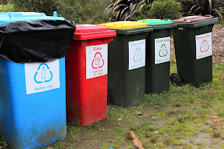
And lastly the rubbish here has to be disposed of in so many different bins: 5 bins for the recycles alone: bottle, can, clear glass, green glass, and brown glass. We would have enough bins to play bowling in our lawns! "Kam pa pei meh" she said in broken Cantonese. The Hokkien lang refuses to be controlled in so many ways.
C 4 - Photos of the trip
Presenting 2 group photos: small group taken at the Botanical Garden in Christchurch and the big group at Milford Sound.
I present here a photogenic shot from the photographer's point of view. It features a butterfly specimen on display at the Invercargill Museum, together with its shadow. Technical data: camera: Canon EOS 600D; f-stop: f/4; exposure: 1/50 sec; ISO: 800; focal length: 30 mm; exposure bias: minus 1.
C 5 - A tribute to the roses
And lastly I present some beautiful roses shot at the Rose Garden, Queen's Park in Invercargill as a tribute to the many roses in our group. Though it is already autumn, way past the blooming period, the roses are still very beautiful.
Thanks for reading.
(First written in the email format in November 2013. Revised to this PDF format in August 2021)











No comments:
Post a Comment