Find Hokkien roots in Fujian, China in 2013
Part 1
(Travel Story Series @ Hon Too Fang 2021)
(Note in 2021: the original email format is retained. Photo quality may be less than desired at today’s standard.)
*********************
My friends,
My boss is a Hokkien lang, once a Hokkien sui char-bor, now a siaulean Hokkien lou-ee. In late August 2013 she and her siblings went for a 10-day tour to Fujian 福建, for sight-seeing as well as visiting her ancestor village. I was ordered to tag along. This is the root-finding travel story.
Hope you could learn something about Fujian.
Hon the Hakka
(17-9-2013)
***********************
A - Introduction
Fujian is a rich coastal province in China, about 38% the size of Malaysia with a population of about 40 million. It is a hilly place, with 80% of the land mountainous. The populated areas are at the coast. The capital is Fuzhou with 7.5 million people in the prefecture and 3.8 million in the city.
Since we are on a "root finding" mission I would like to talk a bit about the history of the province and the history of the people, the "Hokkien lang", since many of my friends are Hokkien lang. My enemies too.
A 1 - History of the Fujian Province
A very simplified version.
The short form for Fujian in Chinese is Min 闽, which is the general name for the 7 indigenous tribes residing in the region some 3000 years ago. When the Qin Dynasty 秦朝 was established in 221 BC, an administrative body, called "Central Min County 闽中郡" was formed to govern this Fujian region. It was the first time in history that this region was included into the Chinese territory. In 723 during the Tang Dynasty, the extended region was divided into 5 counties: Fu 福, Jian 建, Quan 泉, Zhang 漳 and Ding 订. And the general name of the region became Fujian 福建 combining the names of the 2 biggest counties, Fu and Jian. After the collapse of the Tang Dynasty the local warlord Wang Yanjun 王延钧 established his short-lived "Nation of Min 大闽" lasting from 909 to 945. And his territory more or less defined the boundary of Fujian as we know today.
In 1278 during the Yuan Dynasty 元朝, this region was first established as a province 行中书省. During the early Qing Dynasty 清朝 (1644-1912) Fujian and the province to the north-west, Zhijiang 浙江 were combined as one province of Min-Zhi 闽浙, When the People's Republic of China was formed in 1949, Fujian was re-established as a province.
A 2 - History of the people
As was given earlier, the indigenous tribes here were called "Min". During the Warring Period 战国时代 (475 BC - 221 BC), the small nation of Yue 越 in central China was conquered and many of the Yue people migrated to this Fujian region, inter-married with the "Min" and for a while the people were called "Yue-Min". More migrations followed. Two major ones occurred during the Tang Dynasty 唐朝 (618-907).
Talking about migration we have to know two places: Guangzhou 光州 and Gushi 固始. Guangzhou was a county in present-day Henan Province, in ancient time representing the heart of central China 中原. And Gushi was a town within Guangzhou. Around the 660s during the Tang Dynasty, an army officer named Chen Zheng 陈政 from this Gushi area, led an army and families of 7,000+ to settle in Fujian. The people involved came from 58 clans (surnames) including Chen 陈 (or Tan, Chin, Chan as known in Malaysia) Zhang 张, Li 李 and Wang 王. Many of the Malaysian Hokkien lang have these surnames. Then in the 880s in late Tang Dynasty, another army officer, Wang Chao 王潮 from the same Gushi area, led several thousand people and migrated to Fujian, This time 27 clans were involved.
The ancestors of most of the Taiwanese were migrants from Fujian. Survey data shows that 3 out of 4 present-day Taiwanese would trace their ancestor lineage 祖籍 to this Guangzhou-Gushi. I would conclude that most of the Malaysians originated from Fujian could also trace their roots to Guangzhou-Gushi.
A 3 - Fujianese the dialect
The Fujian dialect is now classed as having 5 different sub-groups, namely, North Min 闽北, South Min 闽南, East Min 闽东, Central Min 闽中 and Puxian 莆仙. The type of Fujian dialect common in Malaysia is South Min, Or simply our Hokkien. It is originated from the city of Quanzhou 泉州. Another common Fujian dialect in Malaysia is what we call "Hockchew", popular in Sibu, Sarawak and Sitiawan, Perak. The proper name should actually be East Min with the origin in the city of Fuzhou 福州, the capital of Fujian province.
That is all for history.
B - The UNESCO World Heritage Sites
After the dull history we go sight-seeing. There are 3 UNESCO World Heritage Sites visited. We cover them first.
B 1 - Fujian Tulou, Hua’an County
Fujian Tulou is a unique large-scale compact earth residential construction in mountainous areas in southern China. It flourished in the Ming and Qing Dynasties (14th to 19th centuries). They are found mostly in Fujian province and occupied by the Hakka people. There are some 3,000 tulou in Fujian. Tulou is a gem of traditional Chinese dwellings, adapting to the life of community living and the security requirements to fight against foreign invaders. It could be round, square, or in other shapes. In 2008, 4 individual tulou and 42 more within 6 clusters were officially listed as a UNESCO World Cultural Heritage, including the Eryilou 二宜楼to be introduced here.
We visited 3 tulou in Dadi Village 大地 in Hua'an County 华安, within the prefecture of Zhangzhou 漳州to the south of the province. The big one is Eryilou.
Eryilou 二宜楼
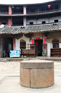
Eryilou is an outstanding representative of the round tulou and is known as the "king of round tulou". It was built from 1740 to 1770. It covers an area of 9,300 sq m with an outer diameter of 73.4 m. It is a double-ring circular earth building with a single-story inner ring, and 4 floors on the outer ring. The total height is 16 m.
For security there are no windows on the outside wall from the 1st to 3rd floors, and only small openings on the fourth floor, to be used to fire arrows or rifles. The outer wall of the outer ring is 2.53 m thick. The bottom layer is made of granite stone, and upper layers with compact earth. The wall is thus firm and solid.
It is divided into 16 vertical units, with a total of 213 rooms. There are kitchens, dining rooms and living rooms on the ground floor, bedrooms and warehouses on the 1st to 3rd floors, and the ancestral hall on the fourth floor, each with individual sets of stairs. The centre is a large inner courtyard serving as a public place. Though in general most of the tulou are homes for the Hakka people, these Hua'an tulou are not occupied by the Hakka tiau, but by the Hokkien lang.
The earth building is well preserved. There were more than 30 households with more than 200 people living there at our time of visit. Cultural elements noted are murals, paintings, wood carvings, old couplets, etc. The 8th photo shows the main ancestral hall, beautifully decorated following tradition.

B 2 – Wuyishan 武夷山, city of Wuyishan
Wuyishan 武夷山 means the Wuyi Mountains in northern Fujian, where an area of about 100 hectares was accorded UNESCO World Heritage Site in 1999. Administratively it is under the city of the same name. The area consists of 4 core parts: scenic areas, nature reserves, ancient historical sites and the Nine-bend Stream 九曲溪 ecological reserve.
We were here on a rainy afternoon and limited our tour to the 2-hour rafting on the Nine-bend Stream and seeing a few historical sites. Shown the rafts made of bamboo, each could sit 6 and operated by 2 "boatmen". Shown some scenes along the stream. The 1st peak featured is Yunufeng 玉女峰, an icon here. The peak in the next photo is the Tianyufeng 天游峰, the main mountain in the scenic area which is accessible with moderate climbing, 800+ steps. We had to leave that to younger legs.
Other tourist activities include watching a show, strolling the Song Dynasty Street 仿宋古街and paying a visit to the Wuyigong 武夷宫, a Taoist temple dated to over a thousand years but re-developed for tourism purposes. In light drizzle.
B 3 - Dajinhu大金湖, Taining County
In China there is a type of landscape called "China Danxia" 丹霞地貌, a land-form resulting from the erosion of red sedimentary rocks, mostly sandstone, characterised by spectacular red cliffs and pillars. In 2010 UNESCO accorded World Heritage Site to a group of 6 areas with such land-form in sub-tropical south eastern China. One of the 6 areas is Taining World Geopark 泰宁世界地质公园 in the prefecture of Sanming 三明to the north-west.
Dajin Lake 大金湖
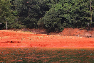
We had a 5-hour cruise on the Dajin Lake within the Taining Geopark. Shown some scenic shots of the cliffs and a pillar. The last photo shows the red earth on the shore, real original colour, no “photoshop” manipulation.
“Lushangxiexiantian" 陆上斜线天
At one of the cruise stops, some of us climbed up part of a low peak through a natural opening in the rock face at a scenic area called "Lushangxiexiantian". The name literally means "a slanting line of sky on land". Here one had to tilt the body sideways to go up. What is shown in the 1st photo is the easy initial part. At the upper and more difficult part the steep opening is tilting sideways at about 20 degrees. When we looked up the sky it was only a line. It took us about 20 minutes to go up. And what is at the top to see? Nothing. Just an exercise. Downhill was easy though, on man-made steps, wider too.


No comments:
Post a Comment