** Part 2: Guatemala **
From Cuba we flew to Cancun, near the eastern tip of Mexico, stayed in this eastern part of Mexico for 6 days. Then we went southwards to Guatemala. We had our 2nd stay in Mexico after visiting Guatemala.
Border crossing
From Mexico we went to Guatemala on a remote land route, from the cowboy village of Frontera Corozal to another cowboy village, Frontera La Tecnica. The countries are separated by the Rio Usumacinta. We had to take a short boat ride and another 2 hours in a van on an unpaved road to complete the crossing.
At the small immigration office in Guatemala:
1st Officer to 2nd Officer: Malas-sia?
2nd Officer to 1st Officer: Malas-sia?
Senior Officer, out from his room, to us: Malas-sia?
We: yes, Malas-sia. Many of our people are malas!
Malaysia is of course an unknown name to many people in these 3 countries we visited. Even the local guides in the tourism industry had no idea about Malaysia. I bet these immigration officers have not seen a Malaysian passport before, not at such remote land entry point. They conferred and had to check if we needed visa or not. Of course we don’t need that. After stamping our passports the officers handed back our passports with both hands and said, “welcome”. With both hands! Have you been treated like that before? I haven’t.
Forgot to mention what happened on the Mexican side: the single immigration officer worked in shorts and slippers in a small front room, with woman’s voices calling him from the back. He probably stays at the back part of the building. That shows how big the office is and how remote the place is.
** Introducing Guatemala **
General
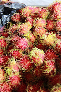
Guatemala is about the same size as Cuba or one-third of Malaysia. A very poor country with per capita GDP around US$ 5,200. 55% of the people live in poverty, and 1 in 5 in extreme poverty. The main exports are agricultural products and minerals. The agriculture sector employs 50% of the work force. Climate wise it is similar to ours. We found “rambutan” in their roadside fruit stalls, but only in one town. There are many humps on the rural roads. You don’t need AES and speed cameras. Drivers automatically slow down after seeing the hump signs. 4 humps in one go? No. Just one hump. That is exaggerated exaggeration!
History
The Spanish came in 1519 and soon founded the colonial New Spain, controlling most of Central America and part of southern US, with the capital in Mexico City. In 1821, part of this region within New Spain formed a Union and declared independence from Spain. The Union soon broke up with civil wars. It was then an illiterate farmer, Rafael Carrera, backed by the Catholic Church, led Guatemala to nationhood. He became the first president in 1844. Subsequent presidents were mostly dictators.
The 1st free election was held in 1944. Since then politics was dominated mostly by military-rule and dictatorship, with fraudulent elections. The problem was extreme poverty and the great disparity of the living standards of the farming peasants and the landowners and those in power. And often the US supported the ruling military junta for fear of the country falling into communist rule. Communist guerrilla uprising started in the 1950s and intensified in the 1970s.
The civil war only ended in 1996 with a peace accord between the guerrillas and the government, negotiated by the UN. Since then the country has made great progress in growth as well as truly free elections.
The following is a poster we could see everywhere. Many of them. And we didn’t see any defaced one. The man featured is Dr Manuel Baldizon Mendez, leader of the Lider Party. This millionaire lawyer lost in the last Presidential Election in 2011. He is getting ready for the next election in a few years’ time.
The point I want to stress is that the posters of an opposition leader are allowed to stand without any defacement. That is political maturity. In Malaysia, the faces of the politicians in the posters will be defaced overnight, whether they are from BN or PR.
(Note in November 2018: he lost again in the 2015 Presidential election)
The people
The population is 15 millions, with 59% Mestizo, 31% indigenous Mayan and 9% indigenous non-Mayan. The Mestizos are mixed-bloods of the whites and the indigenous people. There are very few “pure” whites here, and no blacks too, unlike Cuba. More homogeneous in colour. Religion wise, mostly Christians: 55% Catholics and 40% Protestants.
The Mayan civilization
A travel story on Central America will be incomplete without mentioning the Mayans. The Mayan civilization started around 2,000 BC and peaked around the Classical Period (250 – 900 AD). After that it went into decline and other civilizations took over. But the Mayan people survived until today. Their descendants form sizeable population groups throughout Central America. They maintain a distinctive set of traditions and beliefs, and speak the Mayan languages.
They were excellent in astronomy. Their calendars were accurate and complicated, consisting of counts and cycles. Remember the “End of the World” debacle on December 21, 2012? It was the end of a cycle on the Mayan “Long Count” calendar. Some 'kia-si" people took it to mean the end of the World. The painted calendars are popular souvenir items.
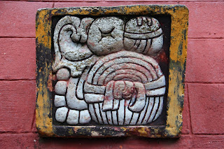
They also have the most complete written language of all the pre-Columbian civilizations in the New World. The Mayan writing system is a combination of phonetic symbols and logograms. It has about 1,000 glyphs. Shown a single glyph and a group of 4 glyphs. A glyph more often represents a phase, certainly more than a word.
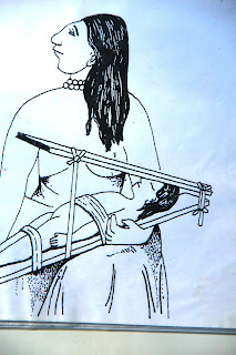
But much of their ancient civilization is not fully understood and remains mythical. For example, flat forehead for woman is considered beautiful? They started to flatten the forehead while she is a baby. Incredible and stupid? Tell that to the Chinese in the late Qing Dynasty. They thought bounded small feet were beautiful!
One great mythical topic is the Mayan astronaut. Inside the Pyramid of Inscriptions in Palenque, Mexico, is the tomb of King Pacal who lived around the 7th century AD. The tomb has a 5-ton cover stone, and the carving on the cover stone was interpreted as an astronaut on his space machine. The Mayan civilization was the work of an astronaut from outer space? You interpret the carving yourself as shown in the 2nd photo! This is a painted souvenir version with added colours. The king is shown in the center of the photo like riding a superbike.
The amazing maize
Corn is the staple food of the Mesoamerican indigenous people. Maize is in fact domesticated by them. The Mayan people, in particular, strongly identify maize as a vital force in their lives. In one of the mythical stories, man was created from maize! The Maize God, appearing in many forms, is central to their altar of deities. Shown a painting of corns, some real colourful corns and a maize god statue.
Day of the Death
On November 2 each year the Catholics worldwide honour those who have passed away. The normal “celebration” consists of attending special masses, prayers and a visit to the graves. They call it All Souls’ Day. For the Mayans who have become Catholics (most are) they add a little of their folklore into the celebration. It becomes a more elaborate affair and they have it on the 1st and 2nd November. It is called The Day of the Death.
Celebrations may include setting up elaborate altars at home, dressing the graves with flowers, cooking of special meals, processions, etc. Many communities have their own special form of celebrations. Flying of giant kites is now a spectacular form in a few towns in Guatemala. On this Day of the Death we were in the very poor village of San Jorge la Laguna at Lake Atitlan. We didn’t see anything spectacular. Shown here small kites hung on the ceiling in our hotel in Antigua, a decorated home altar and the “dressed” graves in San Juan at Lake Atitlan.
**Places visited**
We visited a Mayan ruin at Tikal, overnight in Flores, the old town of Antigua and a few villages around Lake Atitlan. The capital is Guatemala City with 1.1 million people. We didn’t stop here but were caught in a 3-hour traffic jam passing through the city on a Friday evening. Looking out from our maxi van (or mini bus) the city seems to be blooming, with many new buildings and new cars.
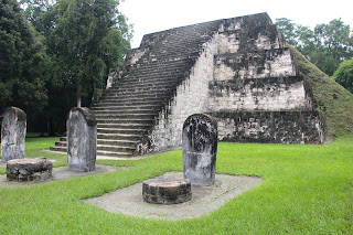
Part of the Grand Plaza and a huge statue. The 2nd series show a view of Complex Q and the Great Pyramid of the Lost World.
The site is very much forested. The 1st tree shown below is the Ceiba, the national tree of Guatemala, a shady tree with long branches found in many of the plazas of the Mayan civilization. Ceiba has many species. The 2nd photo shows one with spikes on the trunk. A Ceiba stick is a lethal weapon. The 3rd one is the Gum tree where chewing gum is made from its sap.
Something strange happened here. On the way out KP walked alone and was in front. But we didn’t see him at the main entrance/exit and we waited, hunted, and finally left on the ticket-pre-booked public bus without him.
He found his way out to our hotel a few hours later, given a fee lift by some American tourists. Luckily he had the hotel card with him. He said he was waiting at the main entrance/exit but he didn’t see us and we didn’t see him on our way out. Simply puzzling. He later admitted that while inside the park he did ease himself against an old tree. He said he did perform the ritual his mother taught him 60 years ago, a hand gesture of “pai pai” and murmuring the Hokkien version of “excuse me”. He said the Mayan god must be angry with him and made him transparent for a while. Sure lah, the Mayan god cannot understand Hokkien mah!
Flores
Flores is the gateway to Tikal. We stayed here for 2 nights. It is a tourist town, part of it an island with road link.
Antigua
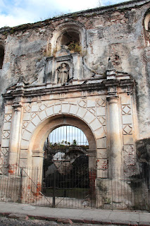
Antigua is a small town in the central highlands of Guatemala, and a formal capital, 1543 to 1776. It is located in an earthquake prone area. After the massive Santa Marta earthquake in 1773 with over 1,000 people killed, the capital was moved to present-day Guatemala City. The present population is about 35,000. It is famous for its well-preserved Spanish Baroque buildings and churches, some in ruins. Show street scenes with the Santa Catalina Arch, an arch joining 2 parts of the old convent. There are quite a number of buildings, particularly churches, damaged by the many earthquakes and remain unrepaired.
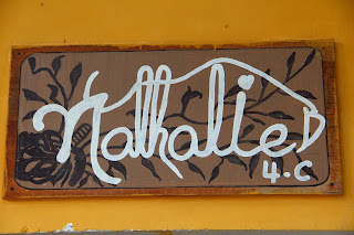
This is also a UNESCO World Heritage Site. For a change I won’t show any more church buildings here, but instead showcase some cute signboards. The business signboards here are well regulated, all very small, not more than 2 ft by 3 ft. Mostly made of wood.
And the colourful buses at the local bus terminal. Most of these are re-conditioned old “school bus” from the US.
**Lake Atitlan region**
Lake Atitlan is a highland lake formed by volcanic activity, about 130 sq km in surface area. Altitude: 1560 m. Depth: up to 340 m. Dotted along the shore are some 10 Mayan villages. The people here suffered badly during the civil war from the 1950s to 1996. The government considered all indigenous people universal supporters of the communist guerrillas. The government pursued a scorch earth policy and committed horrible human rights abuses against them. Many villagers were simply murdered by the armed forces.
We stayed at the village of San Jorge la Laguna for 2 nights, and visited several villages.
Lake view
The lake is flanked by 3 volcanoes, two of them active. Volcano Atitlan last erupted in 1853. Nice twin peaks!
San Juan
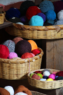
This village is famous for its art galleries and wall murals. The 1st is a painting for sale. The next two are public wall murals, with real vines growing over the murals in the 3rd photo. And a basket of yarn coloured with organic dyes of leaves and animal fats.
The market at Solola
Santiago Atitlan
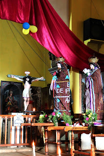
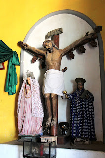
The Santiago Apostol Church here is uniquely decorated with bunting and statues of Mayan-looking saints. We saw similar buntings in other Catholic churches in the Mayan areas. Only Mayan.
Some items for tourists on sale on the street
San Jorge la Laguna
San Jorge la Laguna is a very poor village, with about 5,000 people. 3 out of 4 people live in poverty. The people makes only 1 to 2 US$ a day. The local church is easily the biggest building in the village. Also a group photo showing the "chicken truck" used as our transport in this village. No better vehicles available here.
Home-stay in San Jorge la Laguna
We stayed 2 nights with the Anselmo family. Anselmo is a construction worker and understands a little bit of English. Good-size room, big bed, shared flush toilet but no hot water. We ate dinner together with the hosts and their 3 young children. Our dinner on the 1st night was corn tortilla (like roti canai) with dahl made of tomato, with a piece of boiled chicken half the size of our KFC piece, coffee “thin” like water. No vegetable. On the 2nd night, corn tortilla and red bean dahl. No chicken any more. That is how they survive. My mother’s kitchen on Penang Hill 60 years ago is better equipped.
Our travel mates in other homes had the same story to tell. Some smart travel mates, after seeing what they ate on the 1st night, bought roast chicken back after our day activity on the 2nd day and shared the chicken with the host during dinner on the 2nd night. We the stupid ones bought chocolates for the children instead. Should have bought two whole chickens for the host to feast. Forgot to get out from our ivory tower.
You have to see how other people live only you realize how blessed you are.
Church procession in San Jorge la Laguna
The Catholic community has 3 important statues of the Virgin Mary. And the villagers take turns to house these statues in their homes. Change once a year. The statues are returned from the previous home to the church on the evening of October 31st. And on the evening of November 1st, the statues are moved to the new home. The timing is probably tied to the Day of the Death celebration. We witnessed the procession of the statues around the small town square before the statues were retired in the new home.
More of Lake Atitlan















No comments:
Post a Comment