Wednesday, 15 April 2020

The Istanbul Archaeological Museums in Istanbul, Turkey

*WS 140: the Istanbul Archaeological Museums in Istanbul, Turkey*

The Istanbul Archaeological Museums is a group of 3 museums located next to the Topkapi Palace in Istanbul. The original archaeological museum was founded as an imperial museum in 1891. There are over a million items collected in this museum, including a large collection of Turkish, Hellenistic and Roman artefacts gathered from the vast Ottoman Empire. We visited this museum twice, in 2001 on a “hurrying” group tour and 2017 on our own easy-n-lazy schedule. The photos are of course from the 2017 visit.  

The 1st photo shows the main neoclassical building completed in 1908. The 2nd shows artefacts in the courtyard. The most famous artefacts are a group of 4 sarcophagi from the necropolis of Sidon, a city in present-day Lebanon, dating to the late 4th century BC. The 3rd and 4th photos are images of the most prized possession here: the Alexander Sarcophagus, the stone coffin for Alexander the Great, with the bas-relief carving depicting him (on the far left) slaying the Persians. Another contemporary sarcophagus is the Sarcophagus of the Mourning Women, with aesthetic carving, 5th photo. 

The 6th photo shows the glazed brick panel taken from the way to the Ishtar, the 8th gate in the inner city of Babylon (in present day Iraq), dated to 575 BC. The 7th shows the double sphinx sculpture found in west Turkey, dated to the 9th century BC. Please note that the figure in the middle is too young to be a museum piece. 

The 8th photo shows the famous exhibit from the Museum of Ancient Orient: the limestone statue of Lugal-Dalu, the King of Adab in central Iraq dated to around 2,500 BC.  The last 2 photos show the exhibits from the Museum of Islamic Art, highlighting the use of the famous ceramic tiles produced in the town of Iznik (140 km south of Istanbul) in Turkey during the Middle Ages.


The delightful old town of Cordoba, Spain


*WS 139: The delightful old town of Cordoba, Spain*

Cordoba is a city some 395 km south of Madrid, population: 350,000. It was colonized by the Muslim Moors in the 8th century, became the capital of the Caliphate, ruling over most of Spain. It was recaptured by Christian forces in 1236. The historic old town within the city is a UNESCO World Heritage Site. We were here in 2017. 

The 1st photo shows the Roman Bridge, a masonry arch bridge across the Guadalquivir River, originally built in the 1st century, the present form dated to the Middle Ages. The next 2 show the Alcazar of Cordoba, built in 1328 serving as the court of royals for the Christian monarchs. This is where Christopher Columbus was presented to Queen Isabella to present his plans to discover the New World. 

The 4th and 5th photos show the beautiful Flower Street north of the Mosque-Cathedral, famous for hanging plants and flowers on its walls. The neighbourhood is in fact touristic, selling all kind of souvenirs and curios. The 6th shows the courtyard of the Viana Mansion. The next 4 shows roadside scenes around cobble-stone paved streets, decorations, etc. 

The 11th photo shows the Fosforito Flamenco Centre, with the central decoration shaped like the long gown of a flamenco dancer. Flamenco is a Spanish art form more famous for the dances. Fosforito is a famous dancer, still living and in his 80s. The last photo is a shot of 3 French women taking a selfie in front of the giant poster of Fosforito. I sent the photo to them via email and in return received a long message of love and blessing in French, told by Goggle translate. They were not WhatsApp users.


湖南省湘西的凤凰古城  The old town of Feng Huang in Hunan, China.


WS 138: 湖南省湘西的凤凰古城  The old town of Feng Huang in Hunan, China.

凤凰古城位于湖南省,湘西土家族苗族自治州的西南部。人口约五万,苗族,土家族和汉族聚居。现有的布局始建于清康熙四十三年,历经300多年,古貌犹存。

凤凰古城分为新旧两个城区,旧城依山傍水,沱江穿城而过,以回龙阁古街为中轴,连接无数的石板小巷,沟通全城。旧城有百多栋明清时代的民居,有的已改为商店,酒吧或小客栈。还有三十多座祠庙馆阁。凤凰古城是中国的著名的古城之一。

我们在2009年曾来此旧城区一游。最先的照片所示是沱江两岸,水车。一条小巷的景色和一间有名的祠庙:天后宫。还有一位师父在制作凤凰特产:姜糖,和苗族服饰的小玩偶.

这里较特别的建筑是沱江两岸的土家吊脚楼,依山就势而建,上中层通风防潮,阳光充足,适居。下层是杂室或家禽栏。都是明清建筑。在清浅的沱江上泛舟是经典旅游配套之一。最后两张照片是这里的夜景,在沱江上放莲花灯也是一个旅游节目,看这些卖灯的女孩子都愁眉苦脸,生意该是很差。

(照片质量较差,毕竟2009年的数码相机像素有限)

The old town of Feng Huang (meaning: phoenix) is located in western Hunan Province in China. It has a population of about 50,000, with Miao, Tujia and Han people living together. The existing layout of the town is dated to the Kangxi period in the Qing Dynasty, or about 300 years ago. 

The old town is located at a valley dominated by the main street. There are more than a hundred houses from Ming and Qing Dynasties, some of which have been converted into shops, bars or small inns. There are more than 30 temples and pavilions here. It is in fact one of the famous old towns in China.

We visited this old town in 2009. Shown some typical scenes. A master is shown making the special ginger candy. A feature worthy of special mention is the stilt building on both sides of the main Tuojiang River built by the Tujia people. The upper levels are ventilated, with plenty of sunlight and are living quarters. The lower floors are stores and livestock pens. Cruising on the clear and shallow Tuojiang River is one of the classic tourist packages. 

The last 2 photos show the blurry night scenes here. Floating lotus lanterns on the main river is also a tourism attraction. The girls who were selling the lanterns looked very grim. Business must be poor.


The ruins of Acropolis in Athens, Greece

*WS 137: the ruins of Acropolis in Athens, Greece*

Athens has an old history. By the 5th century BC, the city state was the centre of Ancient Greek and laid the foundation of Western civilisation. The ruins of Acropolis is often taken to be the key symbol of the legacy and the glory of Classical Greece. The Acropolis is a recital on a flattish top of a rock raising 150 m above sea level, with an area of about 3 hectares. It contains several ancient buildings with great architectural and historical significance, most of them built or initiated around the early 400s BC when General Pericles was in power. It is a UNESCO World Heritage Site. 

We visited this place in 2012 on a free-n-easy adventure. Shown a shot from the south-west from below the recital and a distant night scene from the north. The place is on various restoration programs since 1975, cranes are everywhere. Shown an archaeologist at work and a huge tourist crowd at the entrance. 

The 5th is a photo shoot in front of the monumental gateway called the Propylaea. The 6th and 7th photos show the remains of the elegant marble temple of Erechtheion. It is dedicated to the Goddess Athena and Poseidon, the God of the Sea. On the south side of the temple is the “Porch of the Maidens” with 6 female figures as columns. 

The most important temple is the Parthenon, dedicated to the Goddess Athena the Virgin, the city patron. The base of the platform is 69 m by 31 m, with 46 outer columns and 23 inner columns. It is considered the finest example of Greek architecture. Unfortunately it was extensively damaged in 1687 in a war between the attacking Venetians and the defending Ottoman Turks, when gunpowder hid within the building (used as a store) exploded when hit by a mortar. 

The most characteristic feature in the architecture and decoration of the temple is the bas-relief frieze running around the exterior of the walls as shown in the 9th photo. The columns are of the simple Doric order, with simple capitals. Each column has 20 flutes or shallow grooves running vertically down, 10th photo. 

Other notable ruins include 2 theatres. The Theatre of Dionysious was built around 342 BC and later enlarged by the Romans for gladiator fights. The Theatre of Herod Atticus was built by the Romans in 161 AD and was renovated in 1950 for use today for classical concerts, etc.


Lying low at the Dead Sea, Jordan/Israel border

*WS 136: Lying low at the Dead Sea, Jordan/Israel border*

The Dead Sea is really a lake, forming a natural border between Jordan and Israel/West Bank. It is some 50 km long and up to 15 km wide. The surface of the water in the lake is around 430 m below sea level, making the shoreline the lowest point on earth. The lake itself is up to 300 m deep. The figures are taken from Wikipedia in 2020. The shoreline is receding quite rapidly. It was a much bigger lake during our visit in 2008. 

It is fed by the Jordan River. It has no outlet, dead. The salt content is nearly 10 times higher than water in a normal sea, and a person will just float on the surface because of the high density of the water. It is extremely painful if the water gets into your eyes because of the high salt content.

We were here in 2008 as part of the sight-seeing stops in our pilgrimage to Jerusalem. The mineral-rich black mud is also said to be good for skin care. Shown a friend floating and some muddy people!

Qumran is a village located in the desert at the north-western shore of the Dead Sea in the West Bank. In the 1st and 2nd centuries BC, it was home to the Essenes, a small community of Jewish ascetic monastic brotherhood living in caves and tents. What make this place famous are the Dead Sea Scrolls. In 1949 some shepherds discovered 7 ancient scrolls in a cave. Later archaeological excavations on the cliff faces found many more scrolls and these are called the Dead Sea Scrolls. 

These are parchment writings made some 2,000 years ago. The dry weather has helped in the preservation of the writing. They include most books of the Hebrew Bible and the sect’s own works on rules and codes of ethics. The scrolls are now kept in various Israeli museums. The scrolls proved that the Hebrew Bible and hence the Old Testaments (mostly taken from the Hebrew Bible) remained essentially unadulterated over 2,000 years. 

The place is now a national park with ongoing excavations everywhere. The cave right at the spur at the centre in the 4th photo is where the first scrolls were found by the shepherds. We were viewing it from quite a distance away. The last photo was rather interesting with the bright slanting lines of sunlight. The small museum was crowded. Not that we were curious to see the exhibits, it was simply scourging hot outside.


The Sanctuary of Our Lady of Lourdes, France

*WS 135: The Sanctuary of Our Lady of Lourdes, France*

Lourdes is a small town in southern France. From 11 February to 16 July, 1858, the Virgin Mary, mother of Jesus, was said to have made 18 apparitions to a 14 year old simple farm girl, Bernadette Soubirous in a cave near a village in Lourdes. The girl’s later visits to the cave were followed by thousands of curious people. No other people could see the Virgin except her. Various miracles were said to have occurred at the place during that time, under the watchful eyes of the anti-religious government officers with the incidences well documented. One particular case was a clear spring appeared the next day on the spot where the girl dug into the ground and drank some muddy water the day before. 

The water from the spring has since became the source of claims of miraculous healing. The Catholic Church has since set up a Medical Bureau manned by medical specialists in various fields (may not be Catholics) to examine the truth of the claimed healing. Since 1905, more than 7000 cases were submitted and by 2017 the Bureau declared that 69 of the healing cases are considered “beyond scientific explanation”. The religious called them miracles.  

In 1862, the Catholic Church declared that the apparition story was “worthy to believe”. It is up to the followers to believe it or not. A small chapel was first built here in 1866. Now the sanctuary is a complex of many churches and other buildings, to cater for some 6 million pilgrims a year, for hope of healing or spiritual renewal. This is a popular pilgrimage site for Malaysian Catholics. 

In 2016 we made a 4 night pilgrimage stay at this town of Lourdes, which has more hotels in France than any other cities except Paris. The first photo shows the cave where the Virgin Mary was said to have first appeared and a status of her, the likeness as described by the girl Bernadette who later became a nun. Many of the Malaysian Catholic churches have such a grotto set-up outside their church buildings. The next is a scene of a morning mass held in front of the cave. 

The 3rd photo shows the Crypt, the small rock cave chapel blasted out of the rock slope completed in 1866. The next shows the Basilica of the Immaculate Conception, the 2nd of the churches to be completed, in 1876, built over the Crypt. 

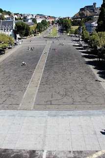
The 5th photo shows a photo of our big family group in front of the 3rd church constructed: the Rosary Basilica completed in 1901. The next shows the lateral view of the two basilica mentioned earlier. The 7th is the interior of the Basilica of St. Pius X, also known as the Underground Basilica, the largest of the churches, completed in 1958. The capacity is 25,000. The 8th photo shows the main open space, called the Rosary Square, where processions are held. 

The last 2 photos show scenes of the daily prayer procession at the Rosary Square. There are many volunteers to help the sick or handicapped pilgrims.